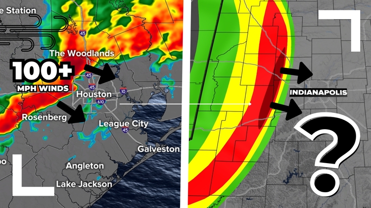
INDIANA, USA — The chance for a damaging wind storm like what hit Houston Thursday evening is actually higher here in Indiana than it is in southeast Texas. Indianapolis has been hit by destructive wind storms before and will get them in the future.
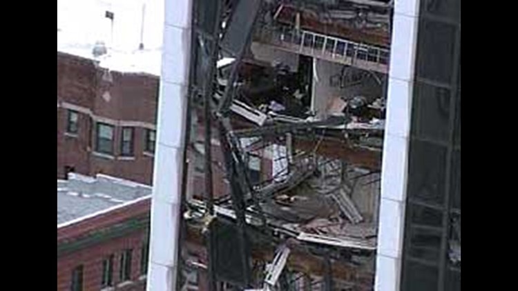
The most recent one to break windows of Indianapolis skyscrapers was back in April 2006 when a derecho (wind storm causing damage over 250+ miles with winds above 75 mph) hit the city, causing major power outages and damage across most of central Indiana.
Tap HERE to see the 2006 storm review from the National Weather Service in Indianapolis for that large wind storm with multiple tornadoes.
(Note: Scroll down to see that damage that wind storms have done to downtown Indianapolis.)
What is the difference between a bow echo, a derecho and a tornado?
Before we move ahead, we wanted to clarify a few terms for wind storms. All of these storms are similar by their intense wind speeds that can cause damage and bring injuries and deaths if powerful enough. The difference lies in how big they are and the pattern that their winds flow:
- Bow echo: An intense wind storm that is created from existing scattered storms or supercells. The cold pool of air behind the storm funnels stronger wind speeds (rear-inflow jet) and a bow or arc forms in the radar data. The bow quickly forces up more warm, humid air to spawn more thunderstorms to keep the whole system running east a great speed.
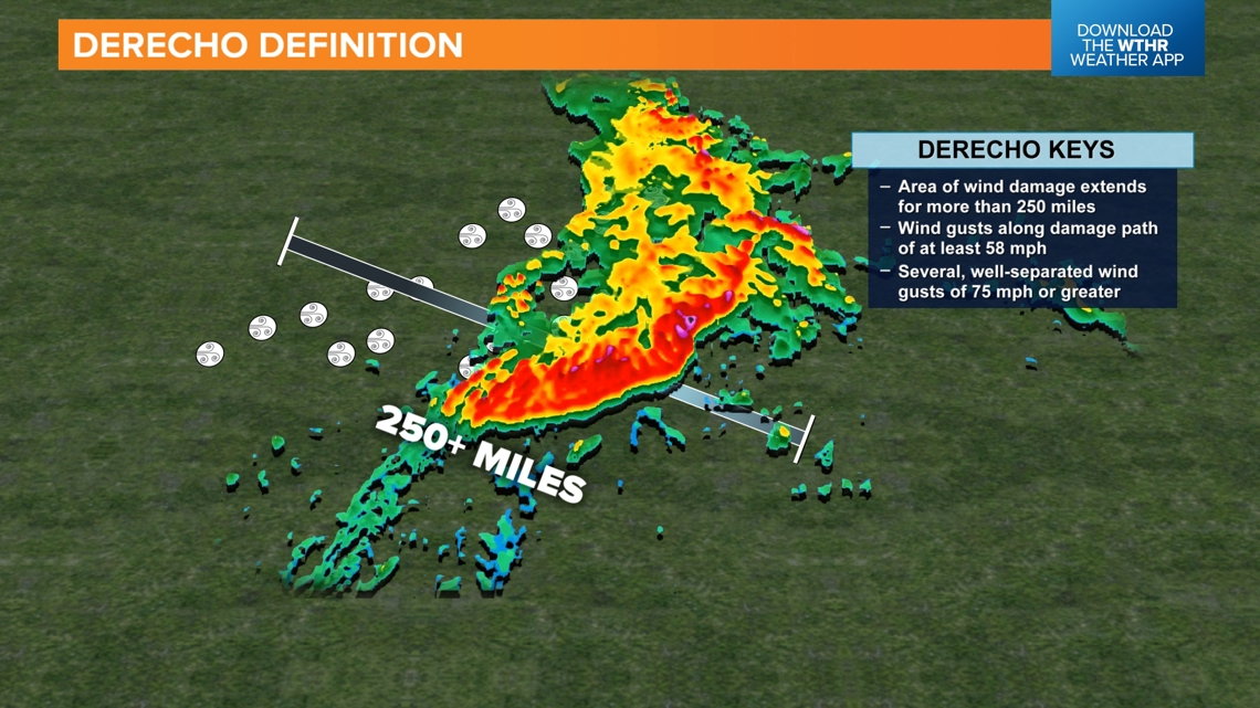
- Derecho: This is a bow echo that charges forward for more than 250 miles causing damage with wind gust speeds of 58 mph or greater. The strongest derechos can have wind gusts over 100 miles per hour and cause widespread damage over a large area. These winds can reach EF0 to EF2 damage.
- Tornado: This is a column of fast rotating wind extending down from a parent thunderstorm to the ground. These wind speeds will usually at least need to be 65 mph (EF0). The strongest tornadoes can have winds over 200 miles. Tornadoes can be very wide, nearly a mile in some cases. They can also track a long ways; however, the damage is only along the path of the tornado.

What happened in Houston?
A powerful bow echo wind storm charged right through the Houston metropolitan area Thursday evening between 5 p.m. and p.m. central. It caused over 1 million power outages. If you want to read more about the damage, our sister station KHOU in Houston has more HERE.
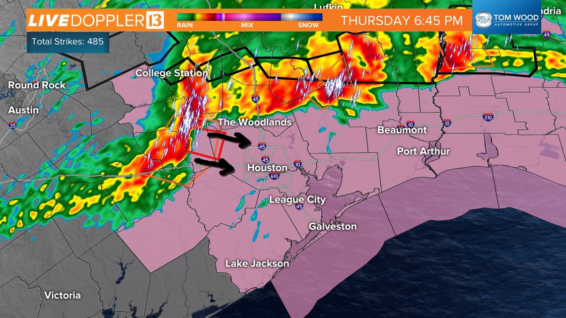
5:45 p.m. CDT (6:45 p.m. EDT) Thursday
A bow echo was starting to form west of The Woodlands with wind speeds greater than 60 mph. A tornadic circulation was also found along the leading edge. A tornado warning and severe thunderstorm warning were issued.

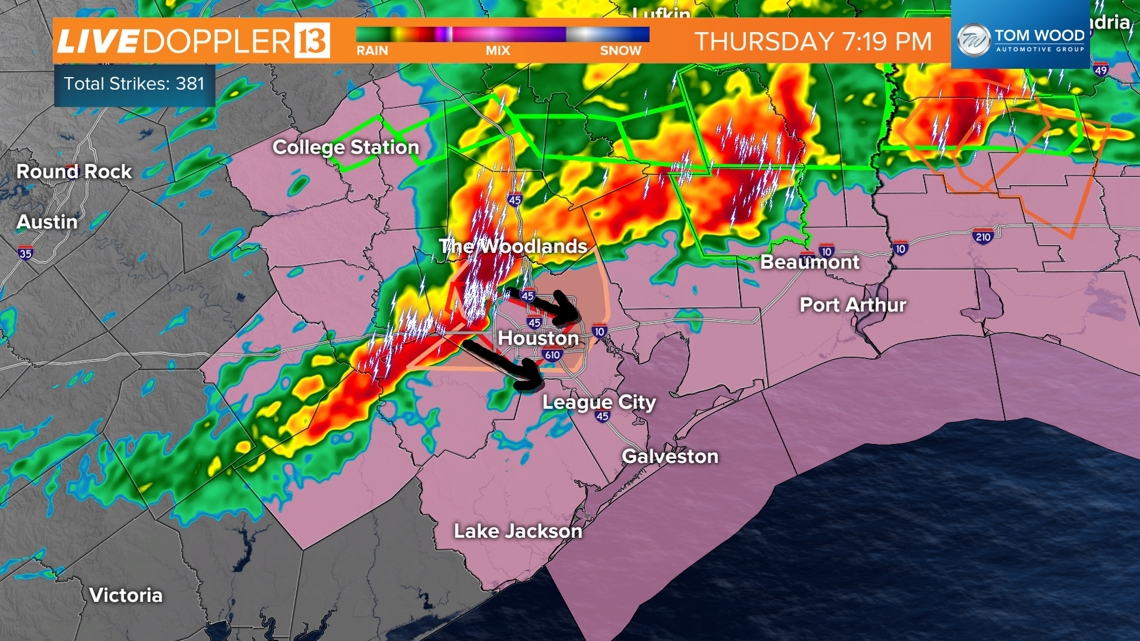
6:19 p.m. CDT (7:19 p.m. EDT) Thursday
The storm started to close in around downtown Houston with wind speeds near 100 mph. A notch in the wind velocities still indicated a possible tornado. A tornado is still likely, but all around the tornado, there were winds near of 100 mph, almost as if a several-mile wide tornado was hitting the city.
The strongest winds are right on the leading edge of the storm.

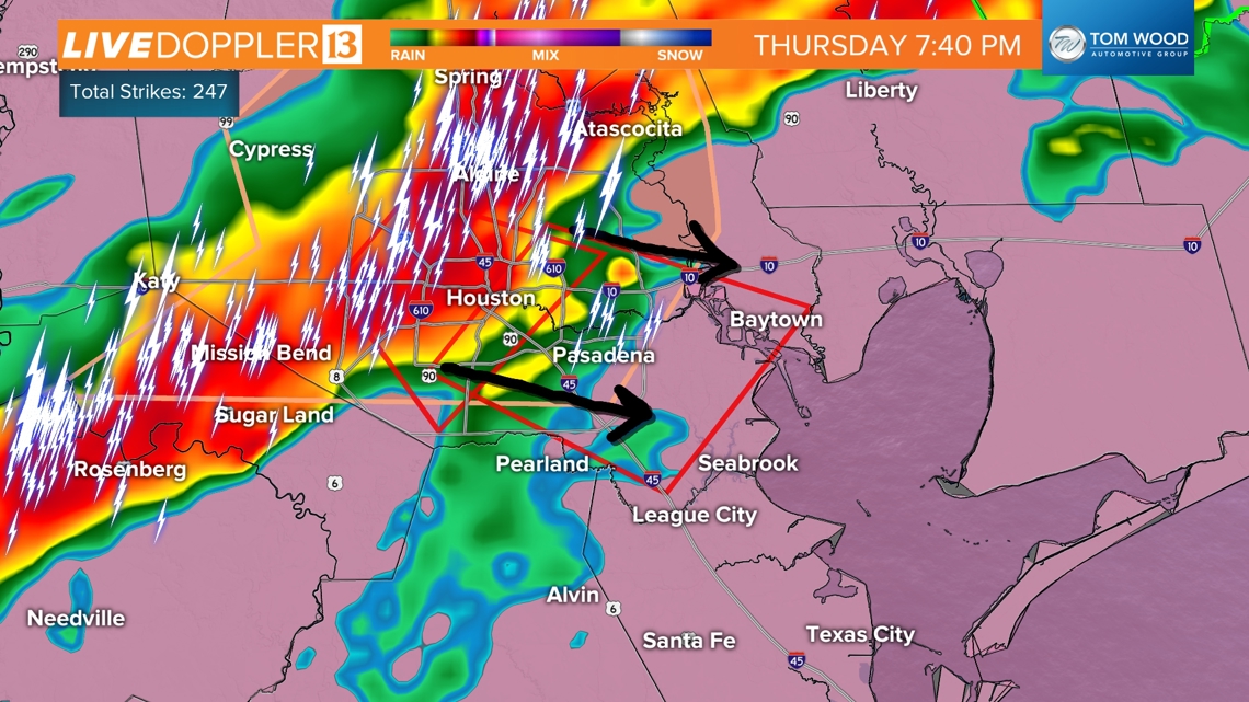
6:45 p.m. CDT (7:45 p.m. EDT) Thursday
The storm slams the city with 90-110+ mph winds and presses southeast toward Pasadena and Baytown.

Was it a derecho? Forensic meteorologists will determine this officially, assessing how widespread and how long the track of wind damage was. This evolving complex of wind storms pressed across much of Texas, but it wasn't reaching severe wind speeds all the time. Nevertheless, it was an intense bow echo wind storm that may be classified as a derecho.
What are the chances Indianapolis gets a wind storm like this? A derecho?
Let's start with Indiana and then focus into downtown Indianapolis.
The Hoosier state has seen a lot of wind storms. On average, we get 170 severe thunderstorm warnings in central Indiana every year. In more active years, we have had over 300 severe thunderstorm warnings with wind speeds 58 mph or greater. These are fairly common, unfortunately.
The storm that hit Houston was not an ordinary storm. It brought 90+ mph winds and traveled a long way across Texas, strengthening once it got closer to the coast with Houston and Pasadena. That's more rare. It can happen every few years here. On average, we get a derecho (one widespread destructive wind storm for 250 miles) about once a year.

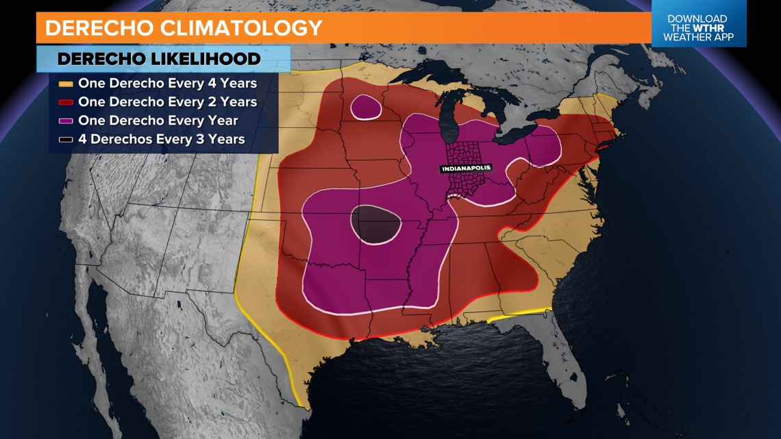
This map from NOAA shows how often we can expect a derecho. In Indiana, that's about once a year.
So what about Indianapolis?
When we ask questions about an individual city, we have a smaller target. While Indiana can get a derecho once a year, it doesn't mean the strongest part of the storm will hit Indy all the time.
The last time Indianapolis had a wind storm that knocked out windows in skyscrapers, damaged buildings and infrastructure, and caused widespread power outages was in April 2006.
To that degree, we do expect one that intense for downtown Indianapolis at least once every 10+ years. However, weaker ones can hit Indy about once a year.
Indianapolis has been hit before... Broken glass on skyscrapers
The last derecho to really hit Indianapolis badly with widespread damage was April 2, 2006 around 8-10 p.m.. This storm hit the entire state. The severe part of the storm extended from Lafayette to Evansville and marched east across all of Indiana. Severe thunderstorm warnings lined the whole thing, but multiple bookend vortices with tornado potential activated tornado warnings all around and inside Indianapolis. (This radar archive is from the Iowa Environmental Mesonet.)

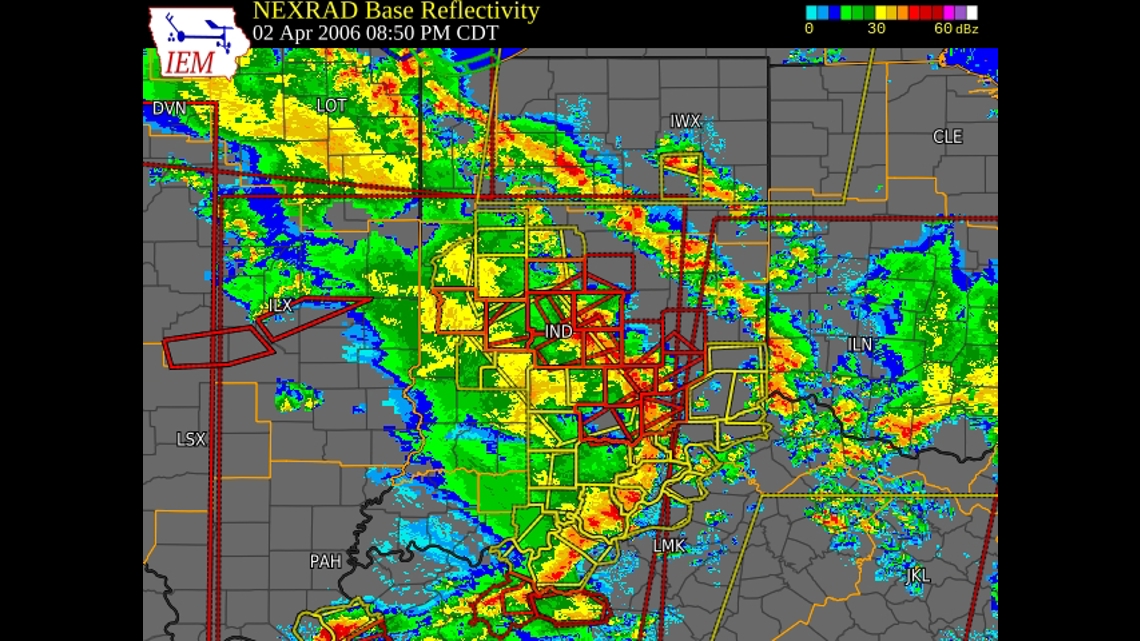
Tornadoes were not the big story, although a few touched down that day in Indiana. The wind was the story. Widespread winds of EF0 to EF2 strength hit the state. That's like a tornado so large it was hitting multiple counties at once.
This map shows all the storm reports from April 2, 2006 (blue dots indicated wind damage).
Downtown Indianapolis wind damage April 2006 Indiana weather
What time of year has the highest chance for a wind storm?
Wind storms are driven by heat and a big temperature difference from top to bottom. You need an intense updraft and some upper-level winds to channel down toward the ground. While wind storms can take place any time of year in Indiana, they are most common in the warmer months of May, June and July.

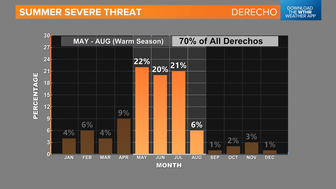
You see a drop off in derecho activity by August and September. It's still warm, but the jet stream is weaker, so sparking and sustaining these storms can be tougher from the upper-level side of things.
Always have to watch for some wind around here. They don't call us WIND-iana for nothing...


