INDIANA, USA — July marks the start to the second half of the year. It is Indiana's hottest month (very close with August) and it can still bring some big downpours and thunderstorm chances.
We will explore what kind of weather the month of July typically brings, and how it may be slightly different this year.
For your latest forecast from the 13News Weather Team, tap HERE.
What is an average July like for Indiana?
It's hot.
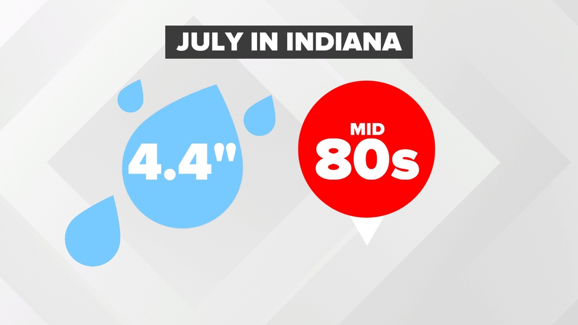
Okay, there is a bit more to it than that. On average, our days are in the mid 80s, however there are many days that are spent in the 90s. During drier years, we can hit some 100s. However, Indiana is far enough north that some fronts pushing across the Great Lakes can skim Indiana bringing some days of slightly cooler air.
August generally keeps the heat going, but we do typically start seeing a tiny bit of a cooldown toward the end of the month into September. There are still plenty of warm days into the fall, but our average high typically starts to drop (slightly).

On average, we can still get some good rainfall during July, especially earlier in the month. Drier conditions start arriving later in the month. August begins the drier half of the year, which helps dry out our crops.
Cornfields and soybean fields are usually still growing in early July. They greatly depend on heavy downpours from scattered storm chances to keep getting tall and full. On average we get 4.4 inches of rain. Many times this is from storms and less from just light rain showers.
Storms in July are very tall, which can really load up on a lot of precipitable water to rain down. Indiana can also get some leftover rains from tropical systems. The hurricane threat goes up and landfalls along the Gulf Coast can sometimes bring heavy rains to Indiana.
What about this June 2024?
Let's start with temperature and then get into rainfall and storm chances.
The first morning of July brought 40s to parts of Indiana, not far from record lows. After a very cool start, there will be a warm up back into the 80s and 90s for the foreseeable future. We are expecting to be slightly hotter than average this July.

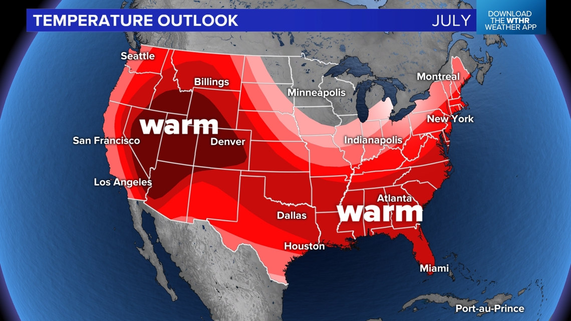
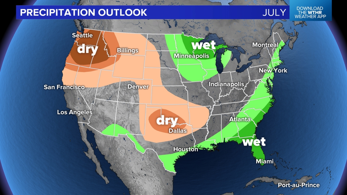
The heat dome does seem to be favoring the western United States for the next few weeks. At times it will move southeast. This should help keep some weak cold fronts visiting Indiana every once in a while. While Indiana is in the red, we still expect a lot of hot days but at least expect some more cooldowns for the first half of July, even if they are weak.
What about rain or storms?
Because of the heat dome moving west, the majority of the drier-than-normal weather will push west. Frequent fronts in the northern Great Lakes will bring wetter conditions across Minnesota, Wisconsin, and Michigan. However for Indiana, we are on the edge. Basically these fronts will get close to Indiana, but it will be tough for them to sit over us for prolonged periods of rain chances. Higher pressure to our south will help break up the rain chances slightly.
We think we may be slightly closer to average for rainfall, but it will depend on how much we can squeeze out of these northern fronts.

Widespread weather threats start to weaken for Indiana in July. We may still get wind storms, but the hail threat goes down as we heat up and can melt icy hail stones faster.
We have to watch for "ridge riders." These are storms that form on the outside of heat domes. This could be a higher threat this July 2024 because many times the heat dome will be centered just outside of Indiana. These pop-up storms out on the edge can be brief but intense with heavy rain and wind.

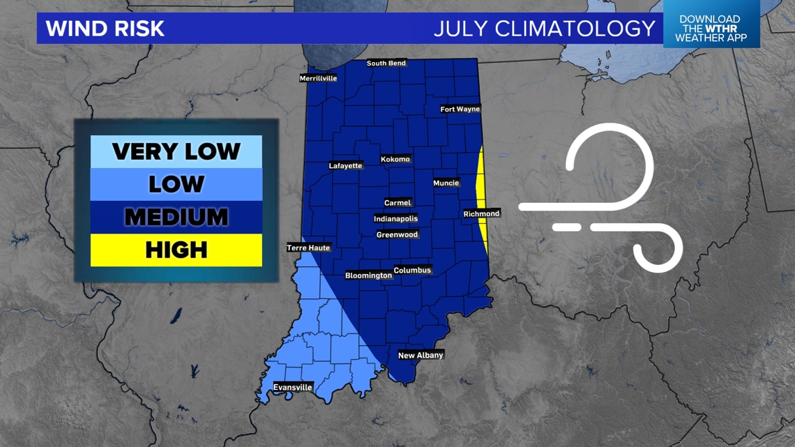
Overall the highest wind threats are typically in northern and eastern Indiana, a bit farther from the center of the heat dome which is typically farther south and west.
-13News Meteorologist Matt Standridge


