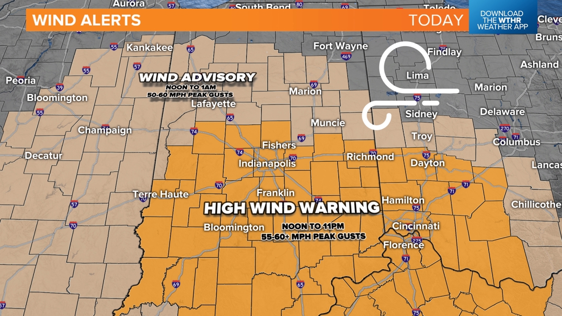
INDIANA, USA — Update: High wind warnings across much of central Indiana will activate from noon to 11 p.m. Friday. Wind gusts 40-60 mph are possible, especially between 4-8 p.m.
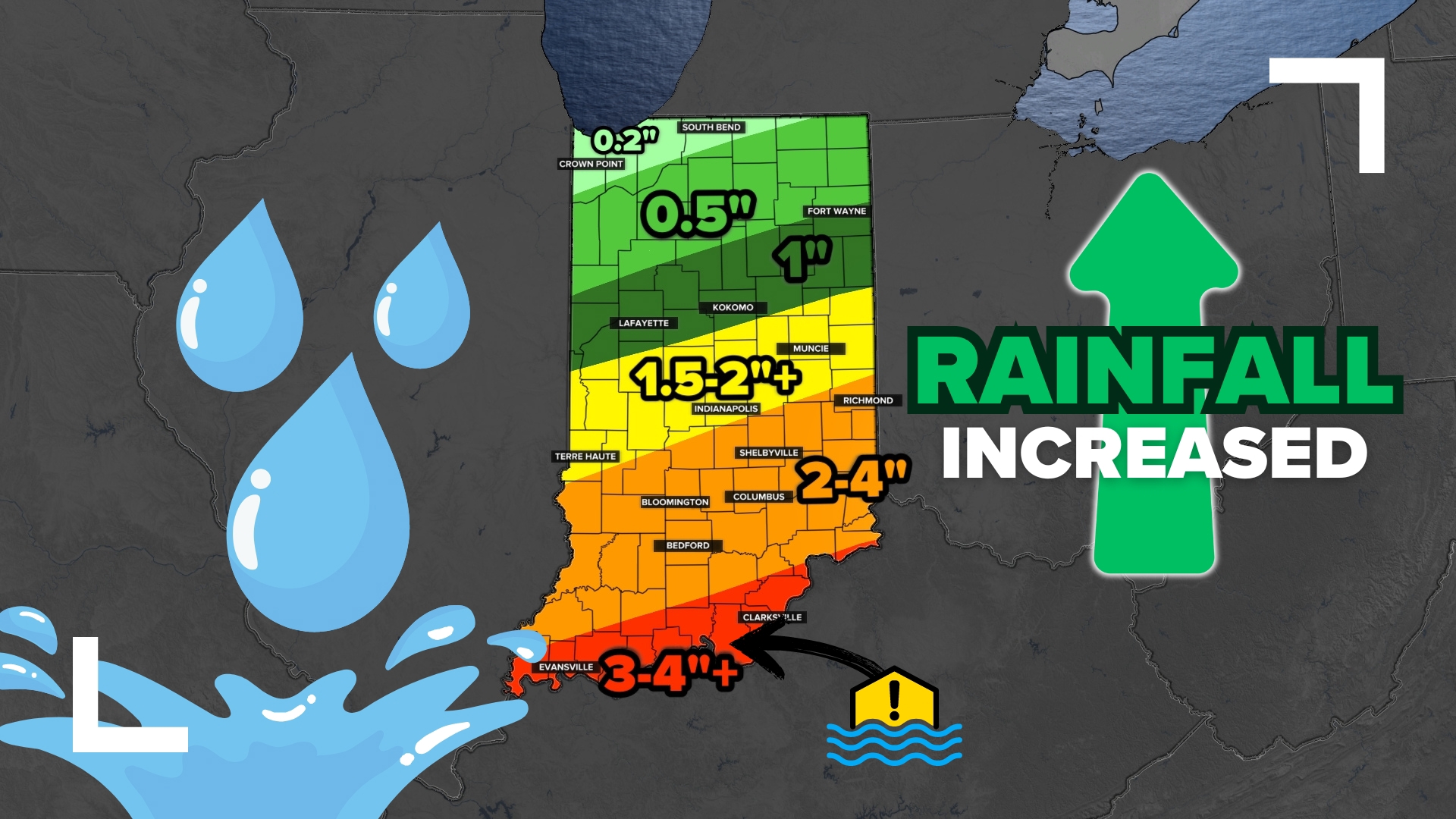
Rain and wind from Helene have arrived here in central Indiana, but the rain forecast has been upgraded. As of 10 a.m. Friday, much of central Indiana had already picked up a half inch of rain.
Tap HERE to track Helene with our interactive radar.
Weather Impact Alert Day
The north end of the eye of Helene will track west over the Ohio River Friday evening, bringing a spike of wind gusts across central Indiana. Widespread power outages are likely with some tree damage. Expect more traffic and accidents throughout the day as well.
Most of Friday, Saturday and Sunday looks rainy. We may get 1-3+ inches of rain across central Indiana.
Rainfall upgrade
While the rain will not be heavy most of the time, the long duration of rainfall will bring some healthy totals across the state.
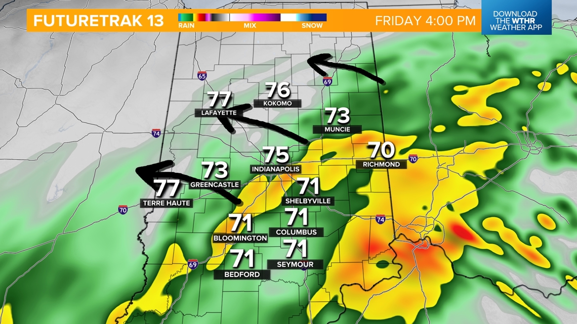
4-8 p.m.: The heaviest rain is likely to fall. We will watch a band of heavier downpours and larger raindrops move in from the southeast and spread across central Indiana in the early evening hours and through sunset. This is also going to be our windiest period.

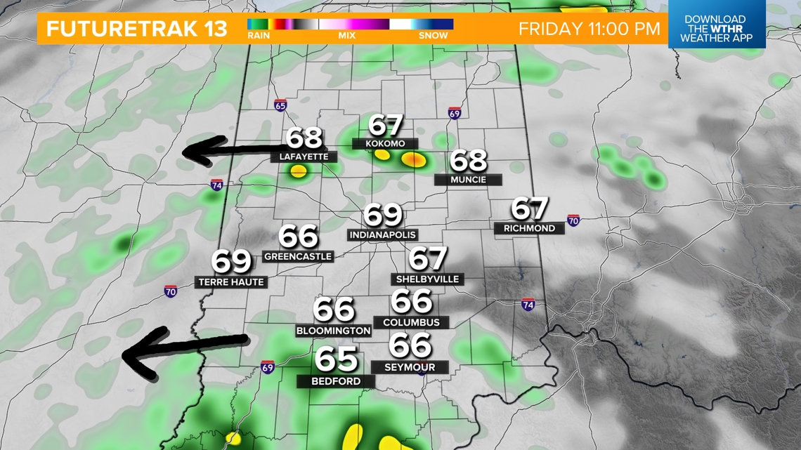
11 p.m.: We will track some drier weather moving in just before midnight. Expect some breaks in the rain overnight into early Saturday morning.

Saturday and Sunday: While heavy rain will be gone, expect showery weather to continue, especially during the afternoon and evening. It will be misty at times, too. An isolated downpours is possible, but most of the rain should be on the lighter side through the weekend.
How much rain to expect
We have upgraded the rain zones across Indiana for the next three days. This will not all fall on Friday. However, a good 60-70% chunk of it may come down today.

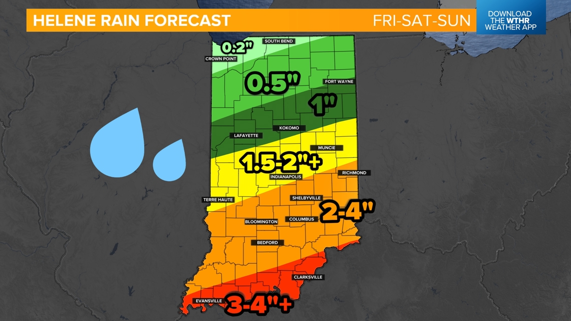
Central Indiana is in the 1.5 to 4" zone. The farther south you go, the heavier the rain will likely be, leading to the biggest totals. There will be a chance for more flooding issues in southern Indiana.
Other than street flooding in some cities across central Indiana, flooding is not our primary concern. Flooding will be a bigger risk in southern Indiana.
Now, let's get to some wind forecasting.
Tracking Helene's wind
Rain from Helene arrived earlier this morning and will continue through the weekend. As we've noted for several days now, it will be windy from now until just after sunset (7:33 p.m.) as Helene's energy gets absorbed into an upper low over southwestern Kentucky. That process is called the Fujiwhara Effect, and what that means for us is a period of enhanced wind gusts due to our northern location of Helene's center track.

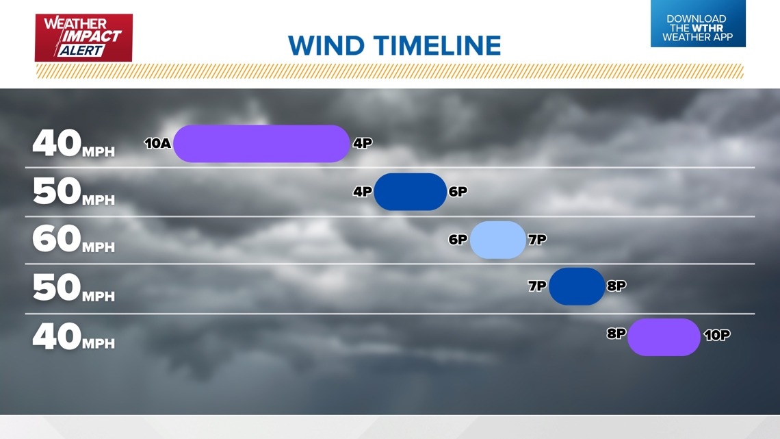
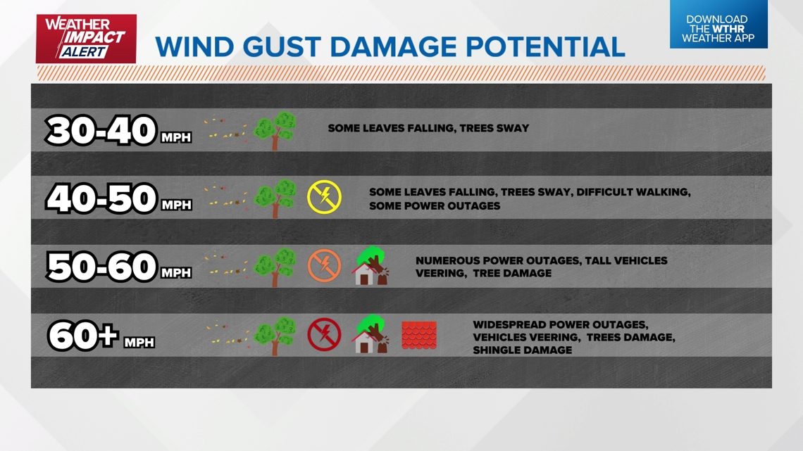
Power outages are already ongoing in Indiana, and unfortunately, the numbers will climb rapidly during a wind surge later today. Wind gusts will be 35-40 mph for much of the day during the aforementioned energy transfer as a surge of higher peak gusts (55-60+ mph) move from east-to-west across the state mainly between 4 p.m.-8 p.m.

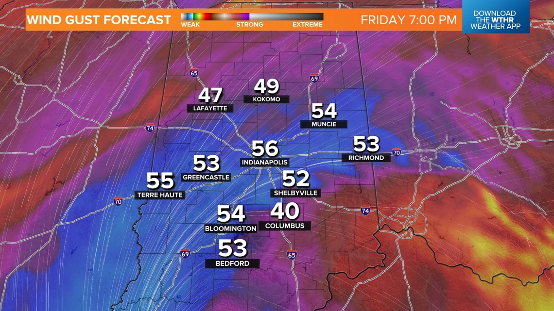
This is when we'll likely see a rapid spike in power outages (tens of thousands — if not hundreds of thousands) during that time, in addition to areas of wind damage. Gusts of 50+ mph can knock down tree branches and make driving difficult. 60+ mph gusts can easily knock over trees and cause some structural damage, too. Due to increasingly wetter ground, the threshold for trees to be dropped will be lower as well.

We urge you to travel with caution if you must be out on the roads today, especially in higher profile vehicles and especially during the time of the strongest gusts.
From east-to-west we're expecting a rapid drop in wind gusts between 9 p.m. and midnight. Though the weekend will remain breezy from the new circulation spinning near the Ohio River, it won't be nearly as strong as what we'll experience this evening. However, you should plan for damp and breezy (20-30 mph gusts) conditions both days this weekend.
The high wind warning will expire at 11p.m. Friday. The wind advisory will expire at 1 a.m. Saturday.