INDIANA, USA — The 80s are about to make a big comeback this weekend across Indiana! A strong warm front is on the move and gusty south winds will jump our temperatures quickly.
Will the warmer air increase our thunderstorm chances? We have a storm outlook for Indiana.
Tap HERE to track the warmer temperatures moving north with our interactive weather map.
It's been chilly lately. After some 40s/50s, clouds, and showers this week, we will jump temperatures by 30 to 40 degrees this weekend. South winds are going to increase up to 20-40 mph.
How warm is it going to get?
For Indianapolis specifically, we expect the 80s to return for the weekend. So far our warmest temperature of 2024 has been 82 degrees (April 15). There's a chance we beat that this weekend.


Average highs in Indiana in late April are in the mid and upper 60s. We'll pass that number by Friday. That's when the south winds will pick up. For the foreseeable future, our temperatures will stay above average.
Across the rest of Indiana, expect even warmer temperatures south and west of Indianapolis. Expect slightly cooler temperatures north and east of Indianapolis.
FRIDAY
- Low 70s
- South winds 10-20 mph
SATURDAY
- Low 80s
- South winds 20-45 mph (very breezy)
SUNDAY
- Mid 80s
- South winds 20-35 mph
How long will this warmth last?
Get used to some of these warmer temperatures; they are sticking around for a while. A cold front may swing through to start the next week, but it won't knock temperatures dramatically. It may just bring some 70s for much of next week. There are no drastic cold fronts on the way for the rest of April. Even the start of May continues to stay warm for Indiana.
Why is this warmth going to last longer?
General answer: Warm-ups survive longer as we approach summer.
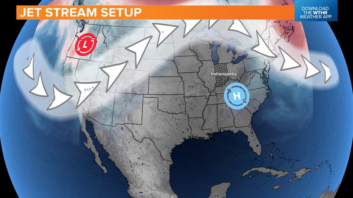
Specific answer: The jet stream is retreating north for a while.


The jet stream helps separate cold air to the north from warm air to the south. The arrows on the map indicate the jet. It will likely keep a big dip in the west. That will keep California cooler. Meanwhile for most of the Midwest, the jet stream has pushed north of the Great Lakes, allowing warm air to move into Indiana and stay in Indiana for a while.
There will be tweaks to this pattern of the next two weeks. Little dips in the stream may push east toward Indiana bringing some storm chances, but generally it will snap back to its dominant position.
High pressure in the southeast is building in a big way. It will help protect the eastern US from major cool downs for a while.
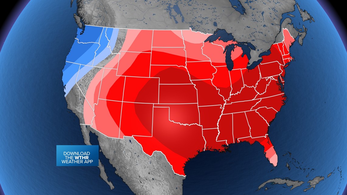
END OF APRIL TEMPERATURE OUTLOOK
The vast majority of the United States will stay warmer for the rest of the month. That includes Indiana. (red is warmer, blue is cooler)


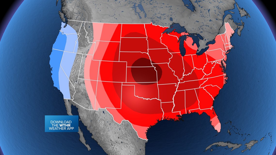
START OF MAY
The pattern for the most part holds for the first week of May.


Will the warmer air bring more thunderstorms to Indiana?
To get severe storms, a rough guideline we use is 60 degrees. If we can't get up to that number, severe weather is tough, but not impossible. (Indiana has had tornadoes with air slightly cooler than that, but generally it's tough.) With highs returning to 70s and 80s for the next couple of weeks, severe weather will be possible.
With the warm weather back in place, now you need fronts to help spark storm chances. With higher pressure nearby, we may get some thunderstorms Friday and this weekend, the strongest storms are likely going to stay in the Plains (green zone).


Multiple rounds of severe weather are possible to the west. However some rounds will try to swing through Indiana, likely at a weaker intensity.
Our best chance for rain and storms moving forward will be Friday evening and Monday. An stray storm is possible this weekend but expect a lot of sunshine too.
For more specific forecast on the rest of the week and weekend, tap HERE.
Enjoy the warmer weather for a while!

