
INDIANA, USA — Scattered downpours kept coming on-an-off all last week across parts of Indiana. Some Hoosiers got soaked while others barely got a few drops. Generally the farther south you live, the more rain you got. Southern Indiana picked up 3+ inches for most counties. Northern Indiana barely got an inch for most counties. Central Indiana was all over the place.
Tap HERE for the latest rain forecast from the 13News weather team.
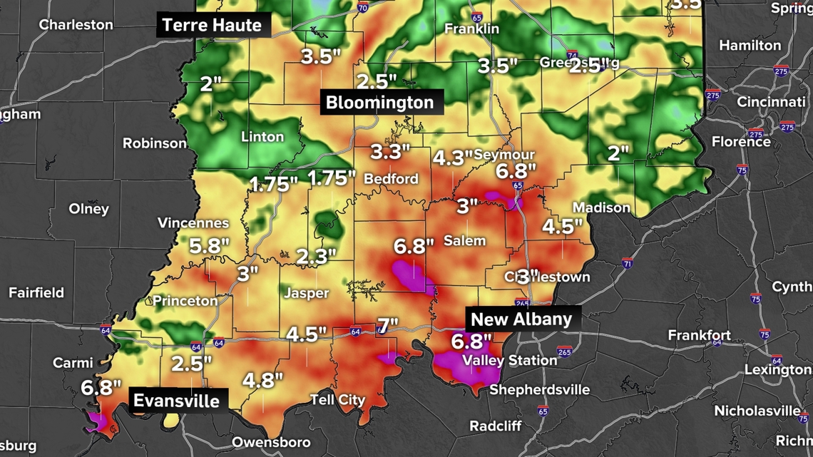
We have a few official totals:
- Indianapolis: 3.33 inches
- Shelbyville: 3.20 inches
- Evansville: 3.01 inches
- Bloomington: 2.00 inches
- Terre Haute: 1.87 inches
- Brownsburg: 1.40 inches
- Fort Wayne: 0.86 inches
- Muncie: 0.86 inches
- Lafayette: 0.60 inches
- South Bend: 0.08 inches
However, these do not tell the whole story. Many times one side of a town got 2-4 inches of rain while the other side of town picked up almost nothing. Instead of official totals, let's look at the radar estimations.

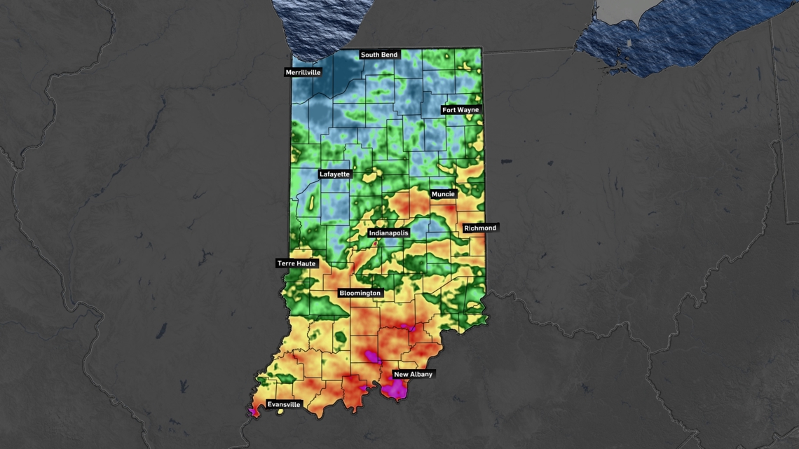
This map shows how much the radar detected across the state. It is not perfect, but it does highlight how scattered downpours drenched some and left others out to dry. Central Indiana was the most spotty in coverage with very high and very low totals, sometimes in close proximity.
For example, the northeast side of Indianapolis had flash flooding with over 4 inches of rain. However, south of Pendleton Pike to Greenfield and Mount Comfort, only light showers came down.
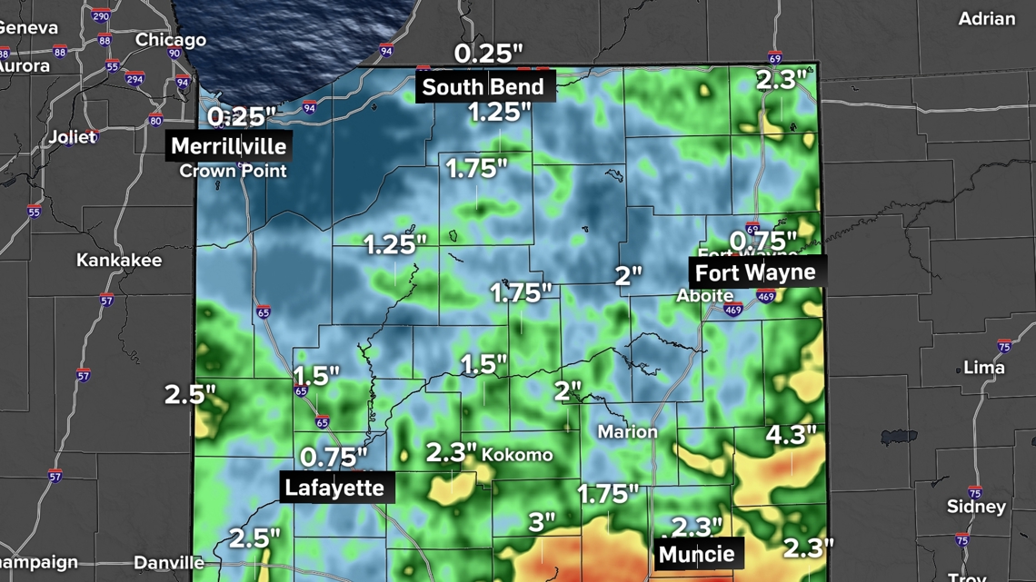
Northern Indiana
The week wasn't very active to the north. Some passing showers came by but most of the big cells were south toward Indianapolis.
However some of the higher totals indicated by green came from Friday as one round of scattered downpours pushed north to south. Otherwise, the week was fairly quiet.

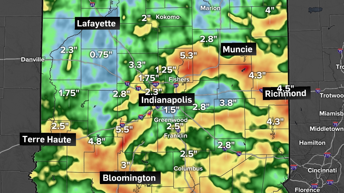
Central Indiana
The rainfall map is all over the place within 80 miles of Indianapolis. The reason why: slow-moving storms. During this time of year, even when the jet stream is overhead, it's not that particularly strong. The upper level current pushing storms around is weak. This prevents downpours from moving pretty quickly. This leads to very heavy rain in spots while other spots stay dry. A storm may rain out before it arrives to a new location.
The heaviest rain for central Indiana was focused along I-465 all the way around Indianapolis, but not so much downtown. The big bullseye was the northeast suburbs from Carmel to Fishers to Noblesville to Anderson and south Muncie. These storms continued east to dump heavy rain for parts of Henry and Wayne counties, too.
Farther to the south, towns just outside Bloomington to the northwest also got a lot of heavy rain.

Southern Indiana
Most of the southern half of Indiana got soaked more consistently. Almost everyone at least picked up 2-4 inches. Some spots picked up over a half foot of rain, especially south spots just outside of Louisville on the Indiana side.

Looking ahead
While July brought several downpours at times across Indiana, expect August to be drier. There will still likely be times of scattered rain, but expect rainfall totals to be about half of what they were for July, roughly. August is typically a lot drier for Indiana.
For the first full week of August, rain chances look slim. A front coming in from the north on Tuesday and Wednesday may bring some isolated showers and storms temporarily, but afterwards expect cooler, drier air to arrive with lots of sun for the rest of the week.
For more on the August outlook, tap HERE.