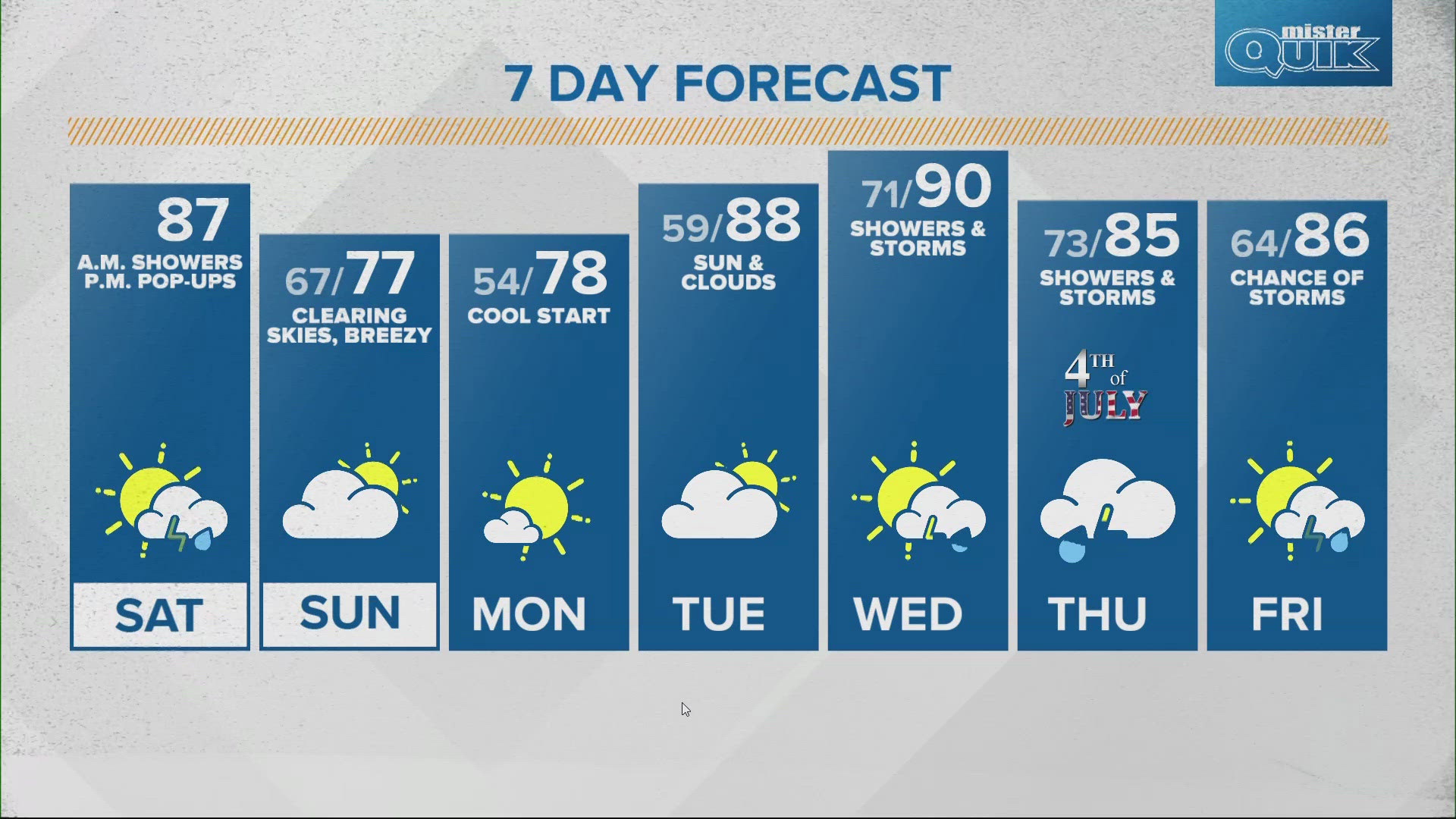
INDIANAPOLIS — The humidity ramped up overnight into Saturday morning, which helped fuel morning thunderstorms.
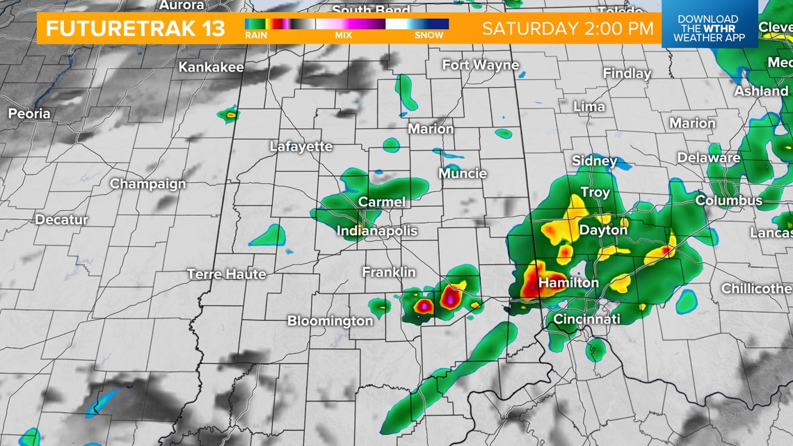
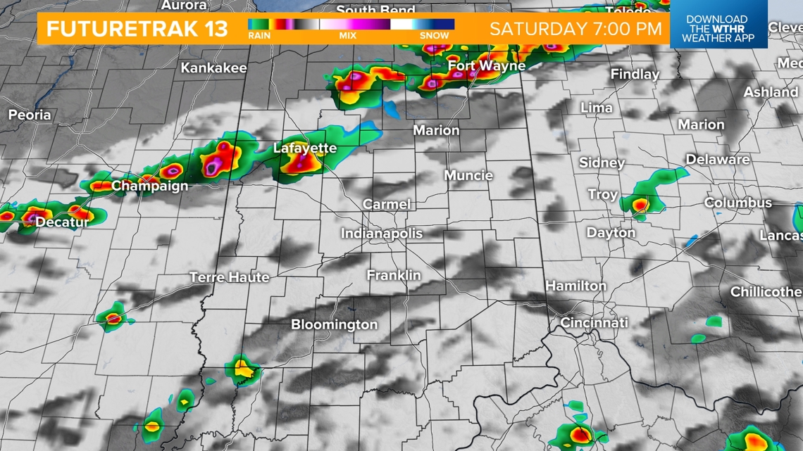
The first round of thunderstorms will begin to wrap up/slide east by late morning/early afternoon.
![](https://media.tegna-media.com/assets/WTHR/images/ba2702e9-889a-467f-a8e7-0775cf9cb82d/20240629T150020/ba2702e9-889a-467f-a8e7-0775cf9cb82d_16x9.jpg)
![](https://media.tegna-media.com/assets/WTHR/images/ba2702e9-889a-467f-a8e7-0775cf9cb82d/20240629T150020/ba2702e9-889a-467f-a8e7-0775cf9cb82d_1140x641.jpg)
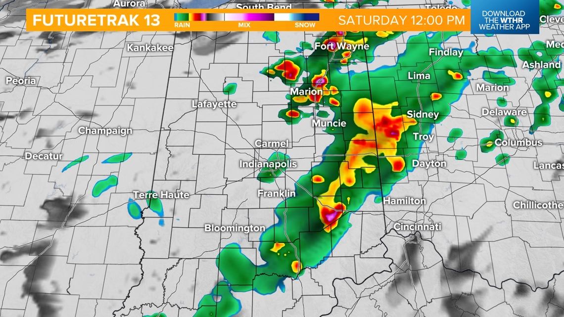
A few isolated storms will still be possible this afternoon, but most will stay mostly cloudy.
![](https://media.tegna-media.com/assets/WTHR/images/ea79b72d-2316-4295-8315-f925658fbe2a/20240629T150045/ea79b72d-2316-4295-8315-f925658fbe2a_16x9.jpg)
![](https://media.tegna-media.com/assets/WTHR/images/ea79b72d-2316-4295-8315-f925658fbe2a/20240629T150045/ea79b72d-2316-4295-8315-f925658fbe2a_1140x641.jpg)
Highs will warm to the middle to upper 80s, areas that received rain this morning will stay a little cooler.
![](https://media.tegna-media.com/assets/WTHR/images/a7a49d0d-9dd7-460b-aaaf-f0bc622b5a4f/20240629T150133/a7a49d0d-9dd7-460b-aaaf-f0bc622b5a4f_16x9.jpg)
![](https://media.tegna-media.com/assets/WTHR/images/a7a49d0d-9dd7-460b-aaaf-f0bc622b5a4f/20240629T150133/a7a49d0d-9dd7-460b-aaaf-f0bc622b5a4f_1140x641.jpg)
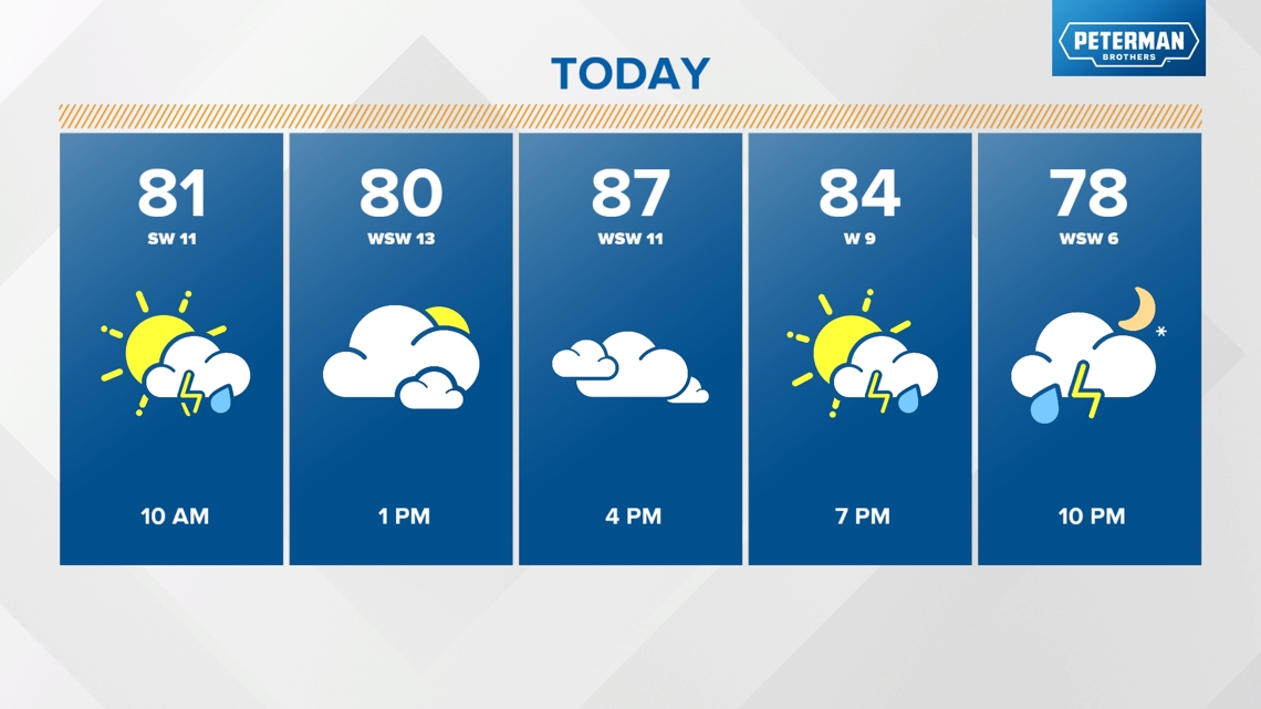
A cold front will likely bring additional thunderstorms after 7 pm through midnight.
![](https://media.tegna-media.com/assets/WTHR/images/d737a87a-da6c-446f-8c4d-beea9869d1cd/20240629T150207/d737a87a-da6c-446f-8c4d-beea9869d1cd_16x9.jpg)
![](https://media.tegna-media.com/assets/WTHR/images/d737a87a-da6c-446f-8c4d-beea9869d1cd/20240629T150207/d737a87a-da6c-446f-8c4d-beea9869d1cd_1140x641.jpg)
![](https://media.tegna-media.com/assets/WTHR/images/aa349bc2-ad61-4e4b-992c-282927ac6643/20240629T150233/aa349bc2-ad61-4e4b-992c-282927ac6643_16x9.jpg)
![](https://media.tegna-media.com/assets/WTHR/images/aa349bc2-ad61-4e4b-992c-282927ac6643/20240629T150233/aa349bc2-ad61-4e4b-992c-282927ac6643_1140x641.jpg)
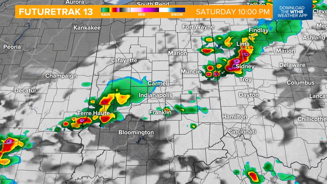
Behind the front a high pressure system will bring dry and cooler air across the region.
![](https://media.tegna-media.com/assets/WTHR/images/c77bc667-7e22-42e8-915c-a52606837559/20240629T150300/c77bc667-7e22-42e8-915c-a52606837559_16x9.jpg)
![](https://media.tegna-media.com/assets/WTHR/images/c77bc667-7e22-42e8-915c-a52606837559/20240629T150300/c77bc667-7e22-42e8-915c-a52606837559_1140x641.jpg)
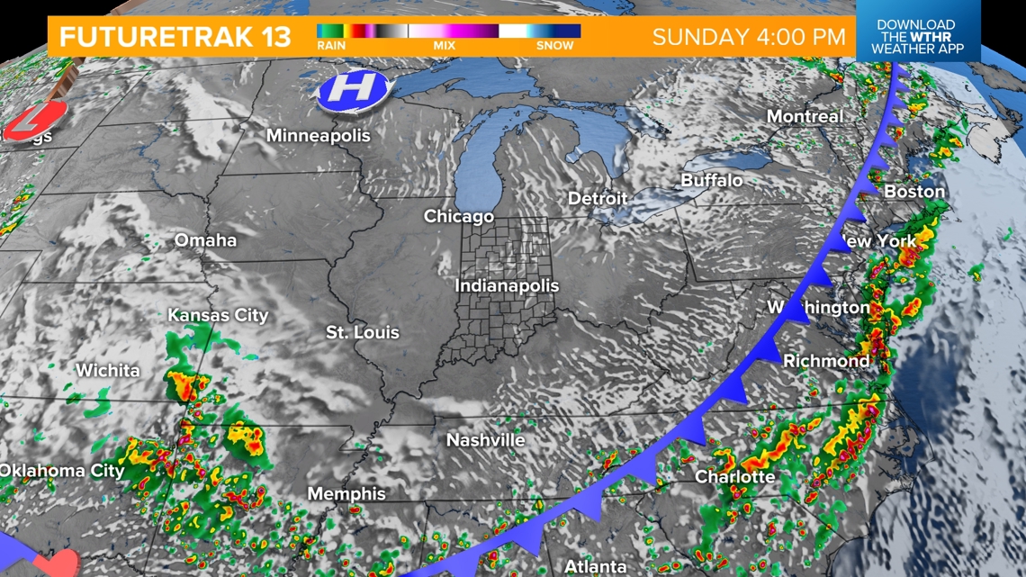
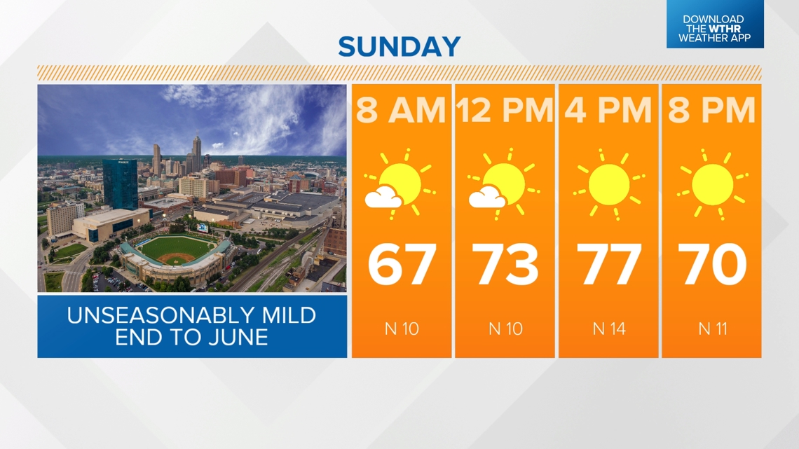
Highs will max out in the middle 70s on Sunday.
![](https://media.tegna-media.com/assets/WTHR/images/c7bd2a66-e273-4d0e-93e0-0de81dbea0cb/20240629T150327/c7bd2a66-e273-4d0e-93e0-0de81dbea0cb_16x9.jpg)
![](https://media.tegna-media.com/assets/WTHR/images/c7bd2a66-e273-4d0e-93e0-0de81dbea0cb/20240629T150327/c7bd2a66-e273-4d0e-93e0-0de81dbea0cb_1140x641.jpg)
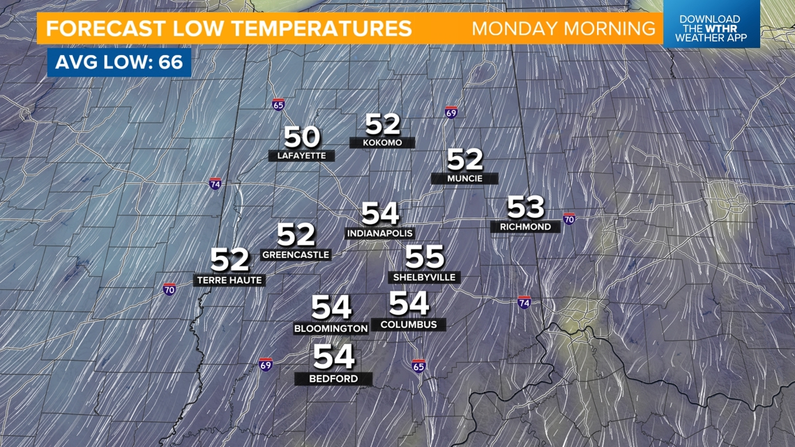
It will be a cool morning on Monday, with early morning lows forecasted to drop to the 50s.
![](https://media.tegna-media.com/assets/WTHR/images/a8b42a15-874a-4bdc-a742-2336fa7f3b52/20240629T150350/a8b42a15-874a-4bdc-a742-2336fa7f3b52_16x9.jpg)
![](https://media.tegna-media.com/assets/WTHR/images/a8b42a15-874a-4bdc-a742-2336fa7f3b52/20240629T150350/a8b42a15-874a-4bdc-a742-2336fa7f3b52_1140x641.jpg)