INDIANAPOLIS — It's going to get worse before it gets better.
This Evening:
As expected, there was not as much storm coverage in central Indiana this afternoon. However, spotty downpours remain possible until a few hours after sunset and the coverage today has been more focused in east-central Indiana, especially in Wayne and Randolph counties. This evening and this weekend it will be a good idea to check radar before heading out or if you're going to be on the lake, especially during peak-heating hours.
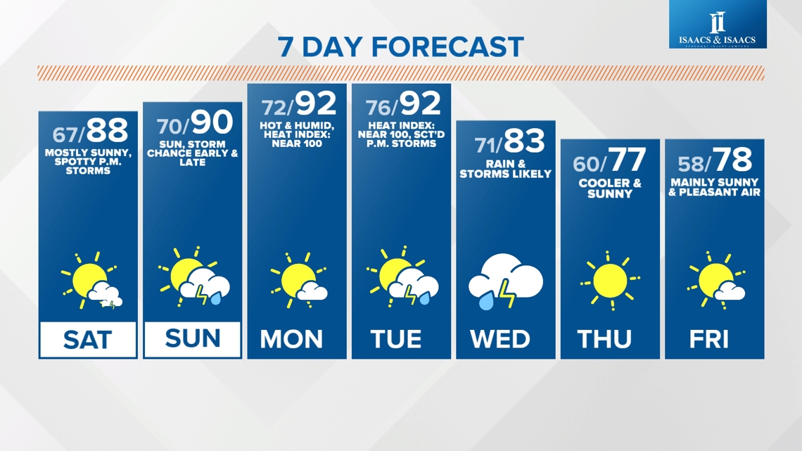
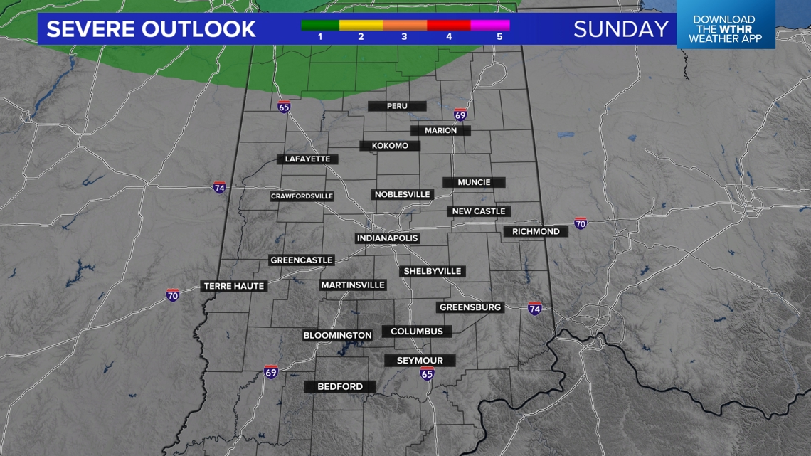
This Weekend:
![](https://media.tegna-media.com/assets/WTHR/images/cded1b10-b470-422a-88e4-1b32814ebbe5/20240712T192422/cded1b10-b470-422a-88e4-1b32814ebbe5_16x9.jpg)
![](https://media.tegna-media.com/assets/WTHR/images/cded1b10-b470-422a-88e4-1b32814ebbe5/20240712T192422/cded1b10-b470-422a-88e4-1b32814ebbe5_1140x641.jpg)
![](https://media.tegna-media.com/assets/WTHR/images/d51b399f-2381-4974-9d98-358427afdea9/20240712T192445/d51b399f-2381-4974-9d98-358427afdea9_16x9.jpg)
![](https://media.tegna-media.com/assets/WTHR/images/d51b399f-2381-4974-9d98-358427afdea9/20240712T192445/d51b399f-2381-4974-9d98-358427afdea9_1140x641.jpg)
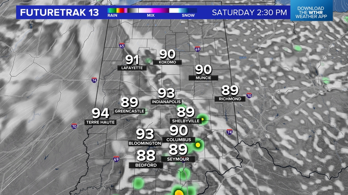
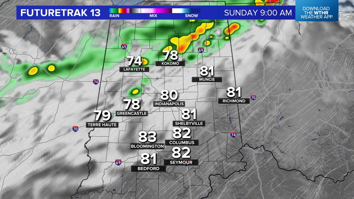
Storm coverage increases a bit Saturday afternoon with the approach of an upper air disturbance. The greatest coverage of storms on Sunday may actually be in the morning from a remnant storm complex drifting in from the northwest. Eventually the atmosphere may become "capped" with too much warm air to limit cloud/storm production Sunday afternoon.
![](https://media.tegna-media.com/assets/WTHR/images/a64ffd15-2ca7-417a-b8a0-d87073838355/20240712T192507/a64ffd15-2ca7-417a-b8a0-d87073838355_16x9.jpg)
![](https://media.tegna-media.com/assets/WTHR/images/a64ffd15-2ca7-417a-b8a0-d87073838355/20240712T192507/a64ffd15-2ca7-417a-b8a0-d87073838355_1140x641.jpg)
![](https://media.tegna-media.com/assets/WTHR/images/d3bdafc7-d792-4108-8e1c-5281b4474105/20240712T192532/d3bdafc7-d792-4108-8e1c-5281b4474105_16x9.jpg)
![](https://media.tegna-media.com/assets/WTHR/images/d3bdafc7-d792-4108-8e1c-5281b4474105/20240712T192532/d3bdafc7-d792-4108-8e1c-5281b4474105_1140x641.jpg)
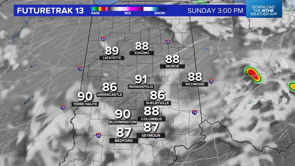
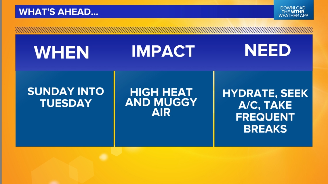
Heat Wave Early Next Week:
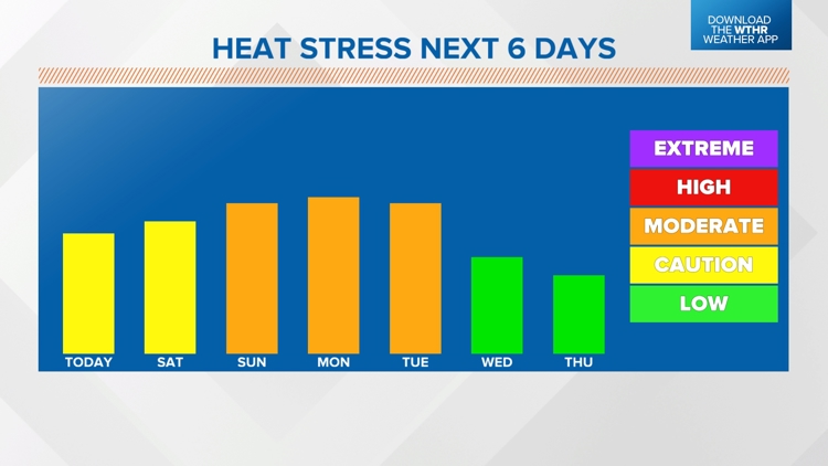
Humid heat remains a big part of the weather story and it will peak Sunday into Tuesday of next week with heat indices near 100° and the Heat Stress Index (combination of temperature, humidity, wind speed, sun angle, and cloud cover) reaching Moderate those days. In that zone it's recommended to take half-hour breaks for every hour you're outside.
![](https://media.tegna-media.com/assets/WTHR/images/bb5ab712-2f8a-4e95-92ac-ebe0a120fa91/20240712T192612/bb5ab712-2f8a-4e95-92ac-ebe0a120fa91_16x9.jpg)
![](https://media.tegna-media.com/assets/WTHR/images/bb5ab712-2f8a-4e95-92ac-ebe0a120fa91/20240712T192612/bb5ab712-2f8a-4e95-92ac-ebe0a120fa91_1140x641.jpg)
![](https://media.tegna-media.com/assets/WTHR/images/f1ce04b4-25ed-4a7c-b9ad-b50e06607e97/20240712T192638/f1ce04b4-25ed-4a7c-b9ad-b50e06607e97_16x9.jpg)
![](https://media.tegna-media.com/assets/WTHR/images/f1ce04b4-25ed-4a7c-b9ad-b50e06607e97/20240712T192638/f1ce04b4-25ed-4a7c-b9ad-b50e06607e97_1140x641.jpg)
Cool Change Ahead:
![](https://media.tegna-media.com/assets/WTHR/images/bbdbc62b-af08-4229-a9ee-2dfd4d9e8bb4/20240712T192711/bbdbc62b-af08-4229-a9ee-2dfd4d9e8bb4_16x9.jpg)
![](https://media.tegna-media.com/assets/WTHR/images/bbdbc62b-af08-4229-a9ee-2dfd4d9e8bb4/20240712T192711/bbdbc62b-af08-4229-a9ee-2dfd4d9e8bb4_1140x641.jpg)
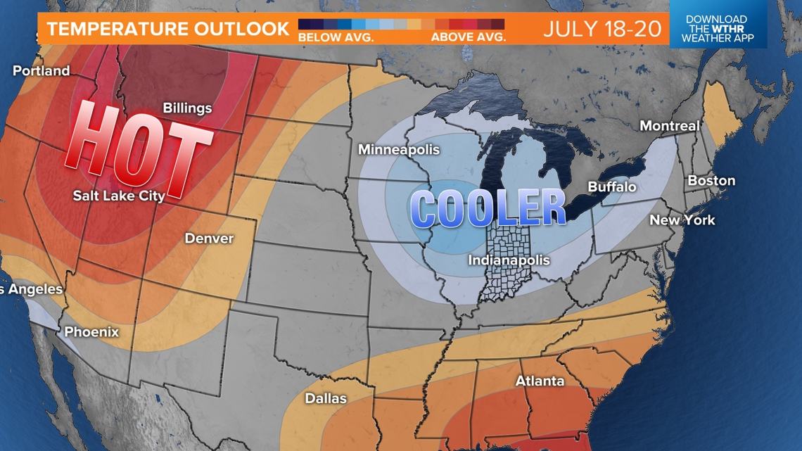
That heat wave snaps in a big way later next week with a 3-4 day pattern shift to much cooler, less humid air Thursday into next weekend. The early call is for a couple of days of highs in the 70s and low in the 50s. If that verifies, it would coincide nicely with the Brickyard 400 this year at IMS.
![](https://media.tegna-media.com/assets/WTHR/images/d79058f8-13d7-493d-b2fb-8b733a6bd570/20240712T192111/d79058f8-13d7-493d-b2fb-8b733a6bd570_16x9.jpg)
![](https://media.tegna-media.com/assets/WTHR/images/d79058f8-13d7-493d-b2fb-8b733a6bd570/20240712T192111/d79058f8-13d7-493d-b2fb-8b733a6bd570_1140x641.jpg)