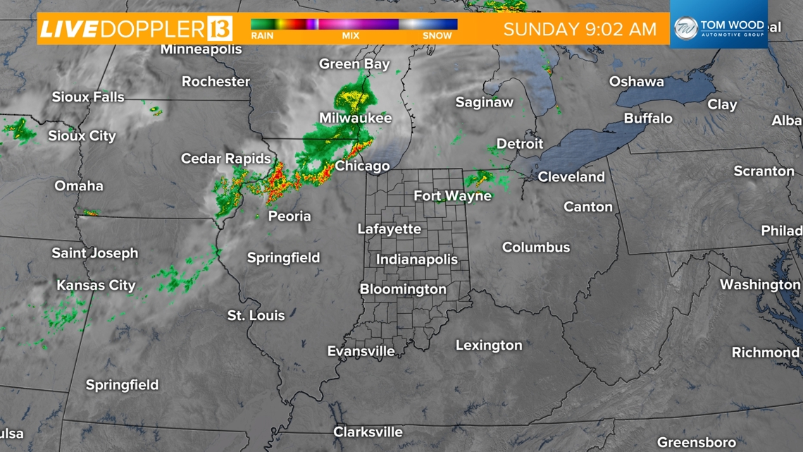
INDIANAPOLIS — We're watching a couple of storm complexes that have been tracking through the Midwest. The initial storm cluster has continued to weaken as it has moved into northern Indiana. A secondary complex is bringing scattered storms into northern Illinois. The lingering boundary could spark pop-up storms later today though.
![](https://media.tegna-media.com/assets/WTHR/images/f6934482-6324-4e8d-9f4e-328850280ade/20240714T152452/f6934482-6324-4e8d-9f4e-328850280ade_16x9.jpg)
![](https://media.tegna-media.com/assets/WTHR/images/f6934482-6324-4e8d-9f4e-328850280ade/20240714T152452/f6934482-6324-4e8d-9f4e-328850280ade_1140x641.jpg)
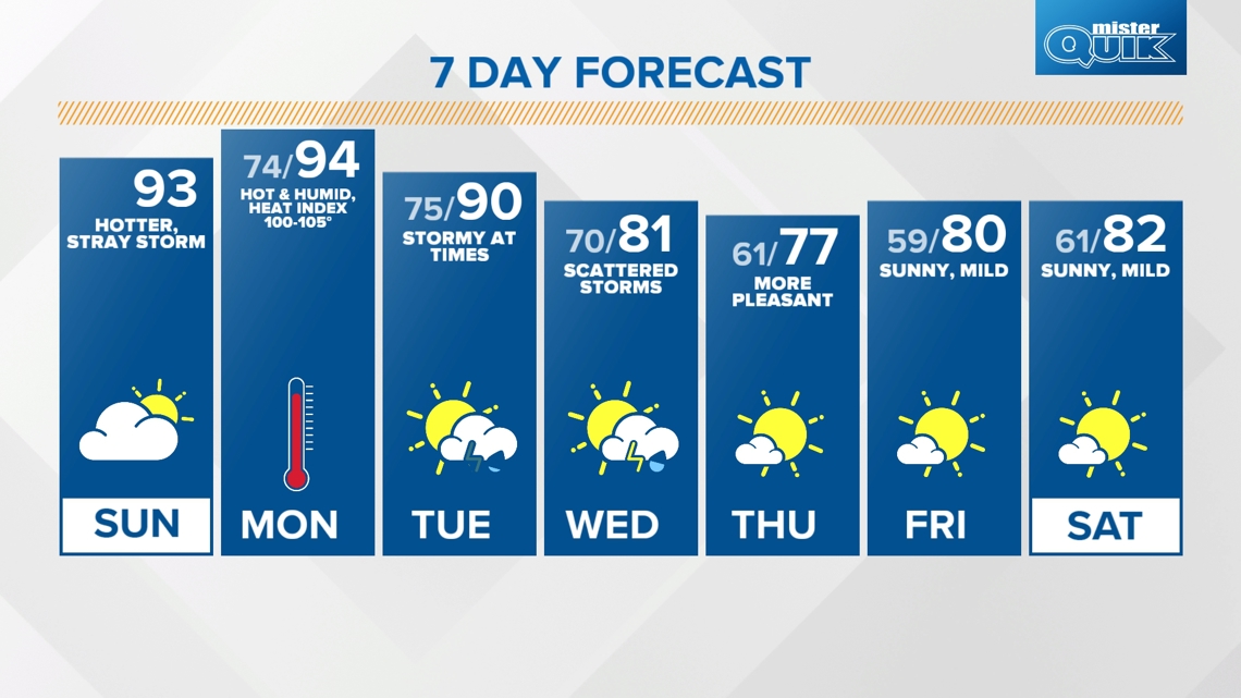
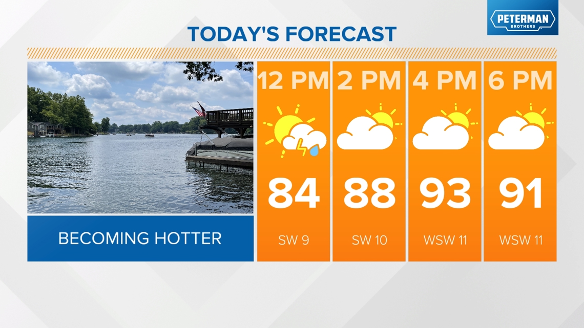
Outside of the occasional storm chance, the hot and humid pattern continues today with highs in the low 90s with peak heat indices up to 101.
![](https://media.tegna-media.com/assets/WTHR/images/a635a91a-6aa0-4b43-8ab0-c4fcf879a0b0/20240714T152516/a635a91a-6aa0-4b43-8ab0-c4fcf879a0b0_16x9.jpg)
![](https://media.tegna-media.com/assets/WTHR/images/a635a91a-6aa0-4b43-8ab0-c4fcf879a0b0/20240714T152516/a635a91a-6aa0-4b43-8ab0-c4fcf879a0b0_1140x641.jpg)
TONIGHT:
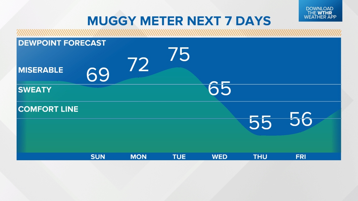
Warm and muggy, warm lows in the mid 70s.
MONDAY:
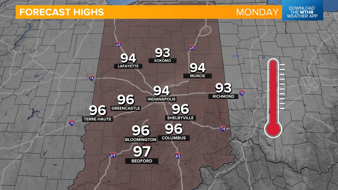
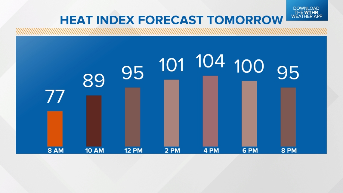
Hottest/most humid day in this heat streak with highs in the mid 90s and heat indices up to 100-105 degrees. Staying mainly dry.
![](https://media.tegna-media.com/assets/WTHR/images/e9a59258-848d-4ca0-a343-f794915b4674/20240714T152533/e9a59258-848d-4ca0-a343-f794915b4674_16x9.jpg)
![](https://media.tegna-media.com/assets/WTHR/images/e9a59258-848d-4ca0-a343-f794915b4674/20240714T152533/e9a59258-848d-4ca0-a343-f794915b4674_1140x641.jpg)
![](https://media.tegna-media.com/assets/WTHR/images/e31a3c22-56b2-4f4d-af35-7bc184280037/20240714T152634/e31a3c22-56b2-4f4d-af35-7bc184280037_16x9.jpg)
![](https://media.tegna-media.com/assets/WTHR/images/e31a3c22-56b2-4f4d-af35-7bc184280037/20240714T152634/e31a3c22-56b2-4f4d-af35-7bc184280037_1140x641.jpg)
When will we see relief from this heat streak?
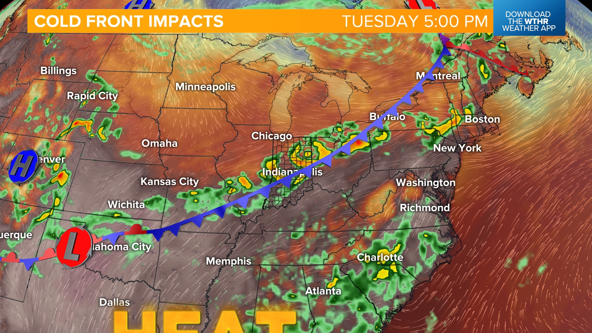
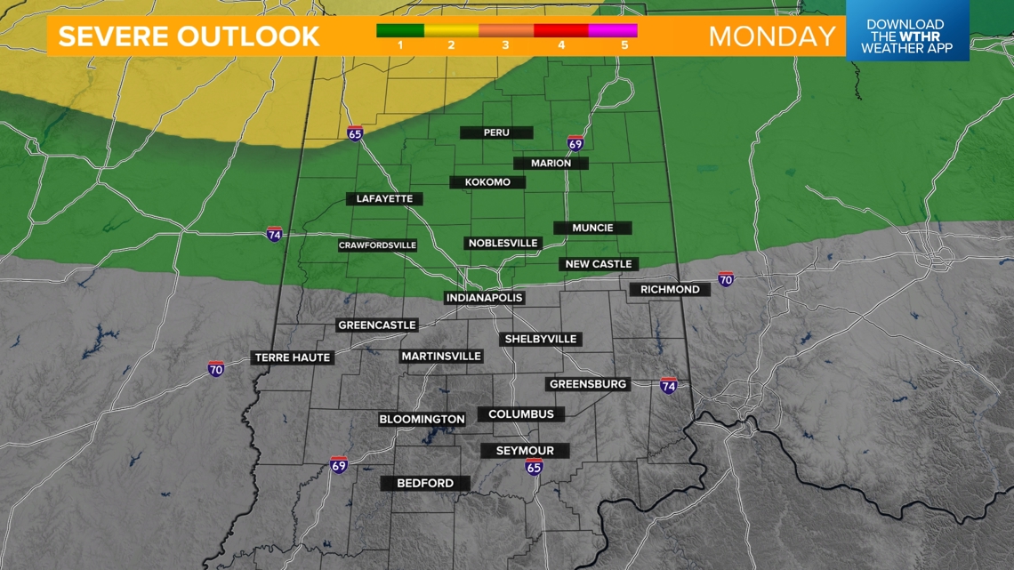
Tuesday will be a transitional day as we track a cold front moving in. This will likely bring a chance of storms into northern Indiana during the early morning hours. The Storm Prediction Center has placed the very northern extent of Indiana in a level 2 of 5 for the risk of severe storms as this initial complex moves in.
![](https://media.tegna-media.com/assets/WTHR/images/b026defb-6e89-458f-8db1-f108e86cc744/20240714T152700/b026defb-6e89-458f-8db1-f108e86cc744_16x9.jpg)
![](https://media.tegna-media.com/assets/WTHR/images/b026defb-6e89-458f-8db1-f108e86cc744/20240714T152700/b026defb-6e89-458f-8db1-f108e86cc744_1140x641.jpg)
![](https://media.tegna-media.com/assets/WTHR/images/e77af028-e176-400c-9c92-97b28b536ecb/20240714T152727/e77af028-e176-400c-9c92-97b28b536ecb_16x9.jpg)
![](https://media.tegna-media.com/assets/WTHR/images/e77af028-e176-400c-9c92-97b28b536ecb/20240714T152727/e77af028-e176-400c-9c92-97b28b536ecb_1140x641.jpg)
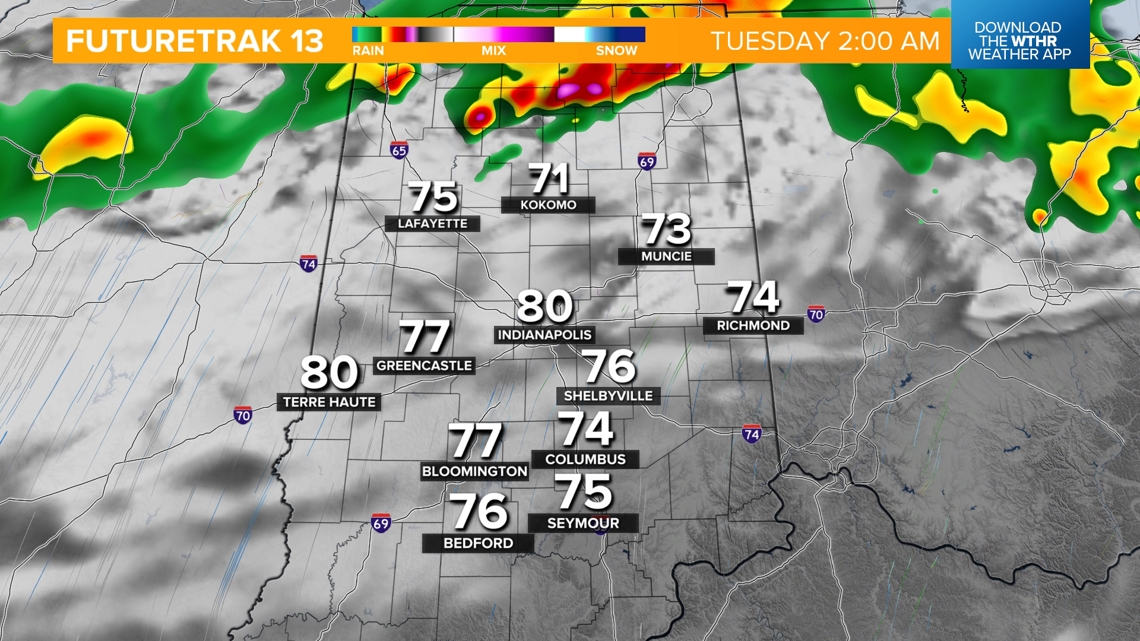
During the first part of the day, the line of storms will continue to push south. While widespread severe storms are not expected, any storm could reach a low-end severe potential with damaging wind gusts as the primary threat.
![](https://media.tegna-media.com/assets/WTHR/images/af9be357-60a1-4a96-894f-8c271b0f84fc/20240714T152749/af9be357-60a1-4a96-894f-8c271b0f84fc_16x9.jpg)
![](https://media.tegna-media.com/assets/WTHR/images/af9be357-60a1-4a96-894f-8c271b0f84fc/20240714T152749/af9be357-60a1-4a96-894f-8c271b0f84fc_1140x641.jpg)
![](https://media.tegna-media.com/assets/WTHR/images/a83d2496-4519-4840-bde5-73063c492367/20240714T152808/a83d2496-4519-4840-bde5-73063c492367_16x9.jpg)
![](https://media.tegna-media.com/assets/WTHR/images/a83d2496-4519-4840-bde5-73063c492367/20240714T152808/a83d2496-4519-4840-bde5-73063c492367_1140x641.jpg)
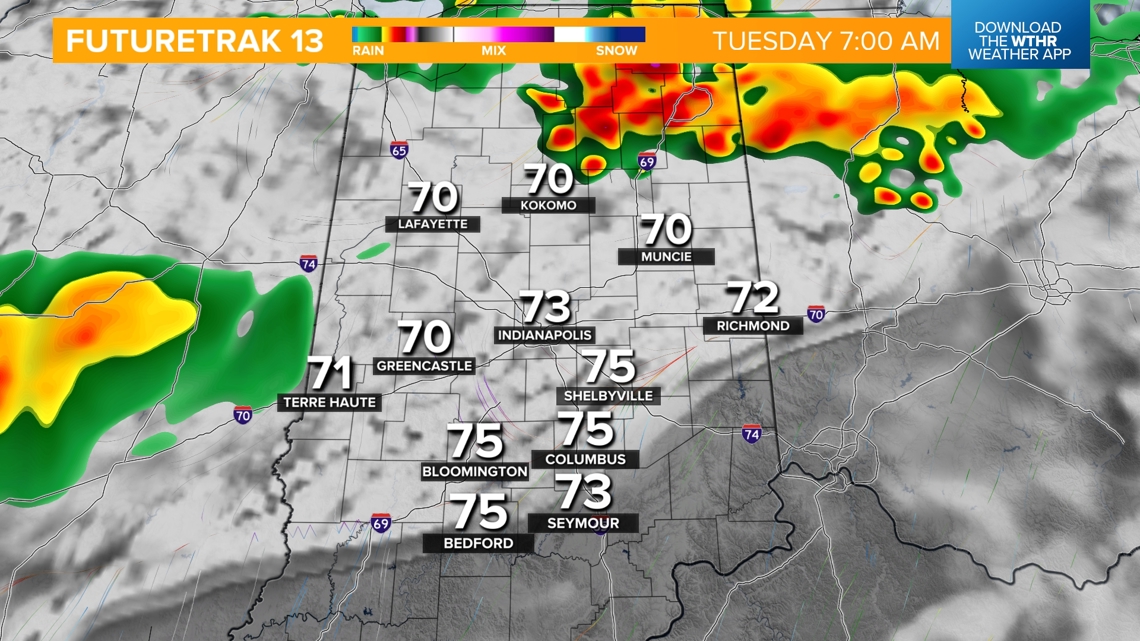
Areas south of the rain and storms will see another rather hot and humid day on Tuesday with highs in the low 90s -- rain-cooled air sets up farther north.
![](https://media.tegna-media.com/assets/WTHR/images/ca357279-e9d4-4a5d-98ed-6c685eae696c/20240714T152832/ca357279-e9d4-4a5d-98ed-6c685eae696c_16x9.jpg)
![](https://media.tegna-media.com/assets/WTHR/images/ca357279-e9d4-4a5d-98ed-6c685eae696c/20240714T152832/ca357279-e9d4-4a5d-98ed-6c685eae696c_1140x641.jpg)
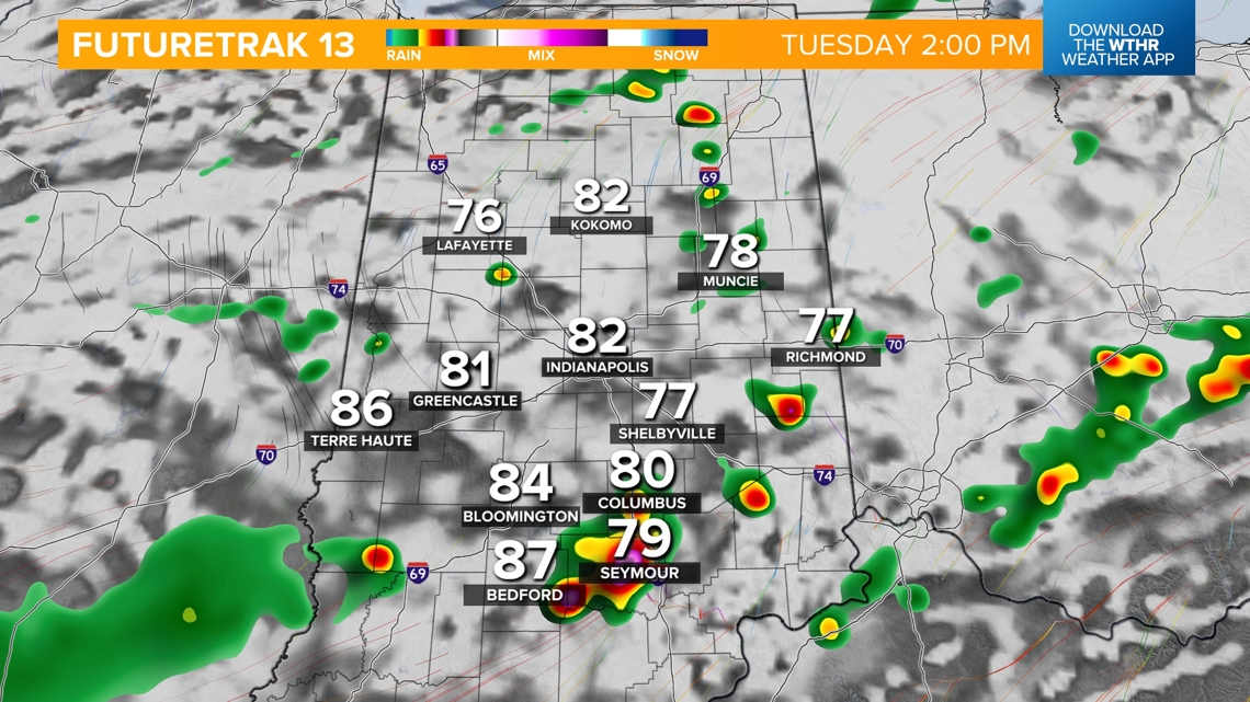
Scattered storms continue Tuesday night into Wednesday morning as the cold front continues to move though.
![](https://media.tegna-media.com/assets/WTHR/images/e1ad1771-c587-4474-b2bd-a6076cf82aec/20240714T152849/e1ad1771-c587-4474-b2bd-a6076cf82aec_16x9.jpg)
![](https://media.tegna-media.com/assets/WTHR/images/e1ad1771-c587-4474-b2bd-a6076cf82aec/20240714T152849/e1ad1771-c587-4474-b2bd-a6076cf82aec_1140x641.jpg)
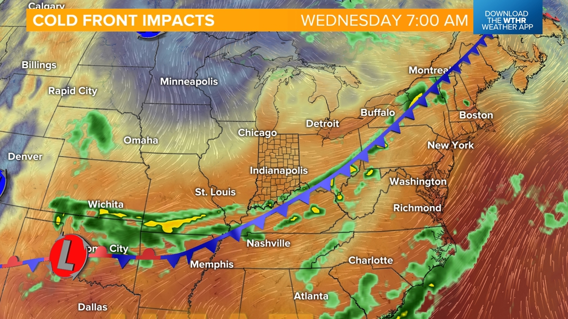
Behind the front, we'll see relief from the high heat and humidity as a more refreshing air mass takes over for Wednesday afternoon through the end of the work week.
![](https://media.tegna-media.com/assets/WTHR/images/a474dac1-7230-4185-802e-4e7e2cbd3c98/20240714T152909/a474dac1-7230-4185-802e-4e7e2cbd3c98_16x9.jpg)
![](https://media.tegna-media.com/assets/WTHR/images/a474dac1-7230-4185-802e-4e7e2cbd3c98/20240714T152909/a474dac1-7230-4185-802e-4e7e2cbd3c98_1140x641.jpg)
![](https://media.tegna-media.com/assets/WTHR/images/cb2c332f-0377-488a-b765-8ac64f071943/20240714T125854/cb2c332f-0377-488a-b765-8ac64f071943_16x9.jpg)
![](https://media.tegna-media.com/assets/WTHR/images/cb2c332f-0377-488a-b765-8ac64f071943/20240714T125854/cb2c332f-0377-488a-b765-8ac64f071943_1140x641.jpg)