
INDIANA, USA — A new tropical system is developing over the warm waters of the western Gulf. By Monday morning, Tropical Storm Francine may be official. The National Hurricane Center has already created a cone of potential impacts from the storm. Indiana is now included for the remnants of future Francine.
We are increasing rain chances across Indiana, especially south of Indianapolis, for Friday and the upcoming weekend (Sept. 13-15).
Tap HERE for the latest local weather forecast over central Indiana.
What we know
- Waters are warm (85+ degrees)
- Clouds and rain coverage is increasing — signs of strengthening
- Winds are picking up around what will be Francine — pressure is dropping
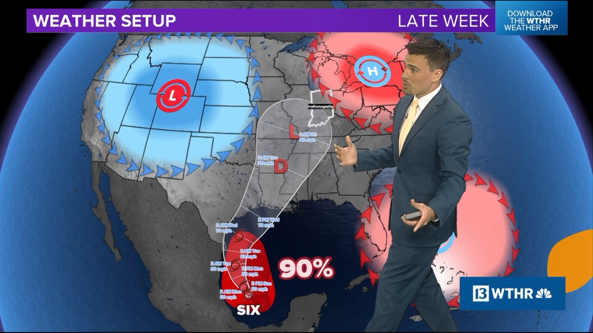
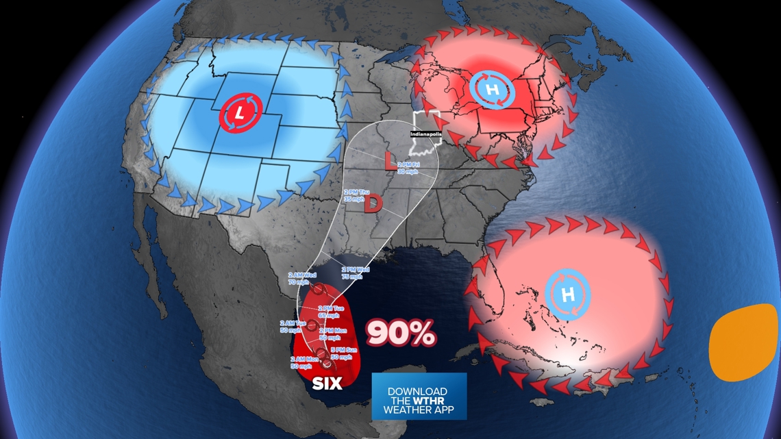
- Steering high pressure is helping the storm go north toward east Texas and Louisiana for a landfall sometime Tuesday or Wednesday
- A half foot of rain will be possible closer to the coast
What we don't know
- How strong will this storm be? Tropical storm status is likely, at the very least. Don't be surprised if we get a low-end hurricane by midweek.
- How much rain will fall farther inland to the north?
- Where will the storm eventually sit and spin with lingering rain chances? Will it be Indiana? Possibly...
- Where will the storm go, depending on steering pressure systems

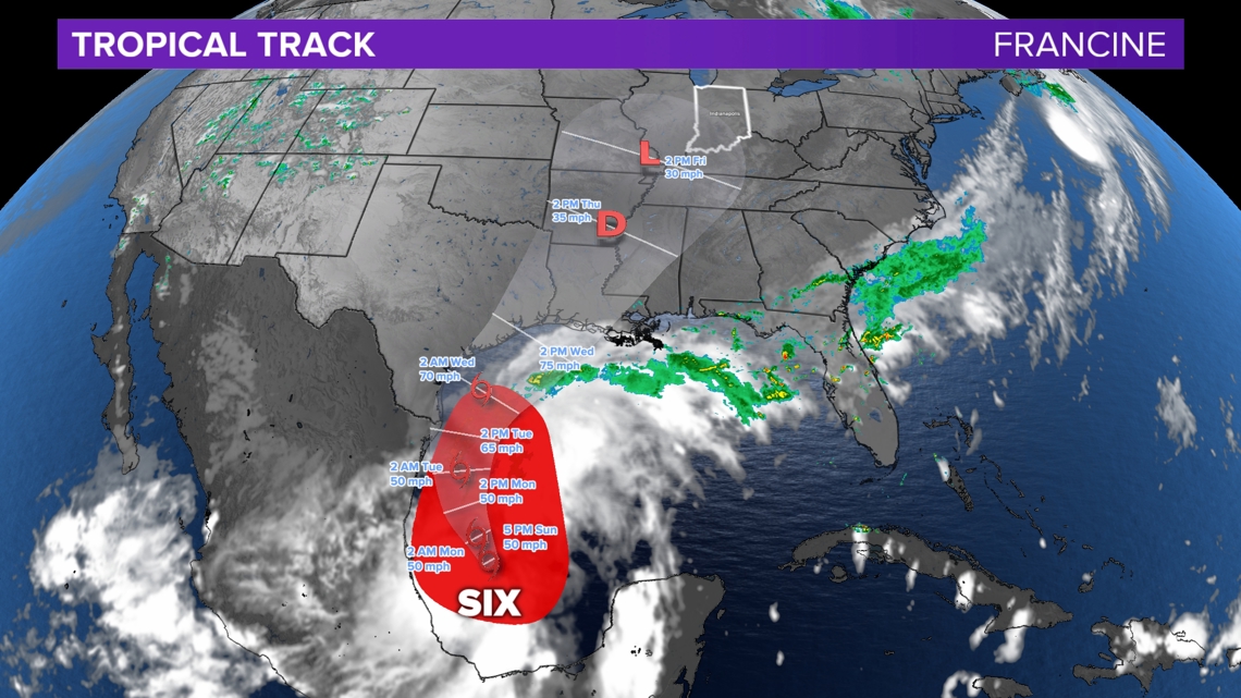
Tracking the potential path
The cone shows the likely possibilities for the center of the storm system. Rain and wind impacts are possible outside the cone too.
We are watching areas of pressure that will help steer this storm over the central U.S. For some, storms like Francine are the only way to bring high rainfall totals this time of year. Some times systems like Francine can help improve drought conditions in areas where September is one of the driest months of the year.
- Low pressure: The jet stream is pointed north-northeast over the central Plains. This should keep the storm system heading just east of due north over the Mississippi River.
- Southern high pressure: This system will help steer Francine due north across the Gulf of Mexico. However it is protecting Florida and Georgia from this storm. Existing rain chances will likely continue this week, but Francine should stay west.
- Northern high pressure: This system will help determine where Francine eventually ends up. Will it break apart over Indiana? Will it be able to sit over the Ohio River, parking itself and dropping lots of rain. We'll see.
Right now we expect this storm to drift north toward Indiana by Friday, bringing some rain chances.

Who gets rain?
This is not a rainfall total map, rather a rain coverage potential map. As the storm pushes north, it will weaken and slowly rain out. However there may still be high rainfall totals farther inland. This map only includes rain chances through Friday (Sept. 13).
- Yellow (soaking): Heavy rainfall likely thanks to numerous rain bands and downpours -- this is the area with the highest risk of flooding
- Dark green (widespread): Lots of rain and downpours will help bring healthy rain
- Medium green (scattered): On and off showers and downpours are possible, but not everyone gets a ton of rain. A few will.
- Light green (isolated): Showers will be more on the fringe, expect some places getting wet while others places remain dry. Rainfall totals may not be high.

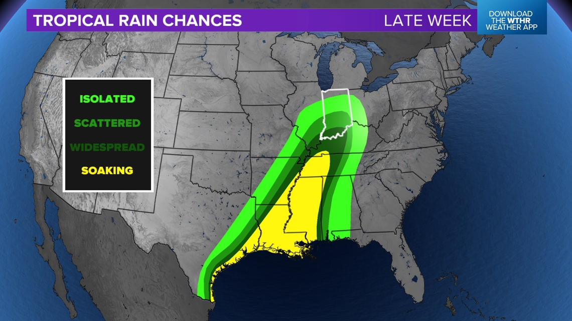
Once this storm fully develops and we know where it is making landfall later this week, we will update rain chances. There's a chance that after Friday, the remnants of Francine sit over the Ohio River, bringing some healthy rain chances for some in scattered coverage.
Check back for updates.
— 13News Meteorologist Matt Standridge