INDIANAPOLIS — Be on the lookout for more snow showers across Indiana! A front will be moving in Friday night, bringing a burst of precipitation, rain changing over to snow. Expect rain showers to arrive after sunset. After two to three hours, you may switch to some snow showers. The heaviest are likely to be in northern and eastern Indiana.
Tap HERE for our live interactive radar to track the next storm moving in.
Tap HERE for the latest detailed forecast for central Indiana over the next couple of days.
Are we really getting more snow?
After a big hit last Friday with several inches across Indiana, this chance is very minor. Expect some snow flurries at times Friday night. The farther south and west you live, the less snow you can expect. You may find a couple dustings here and there. The best chance of snow will be north and east of Indianapolis. As the mesocyclone low moves south into Indiana, the northeast side of the low pressure will likely create a fairly decent snow burst. This is where the highest snowfall totals may be (1-2" or greater).
Our quick rundown:
- Clouds slowly build late Friday evening.
- Rain showers move in a few hours after sunset, changing over to snow.
- Snow burst early Saturday morning, especially north and east of Indianapolis.
- Big warmup comes back by Sunday with more rain/storm/snow chances next week.
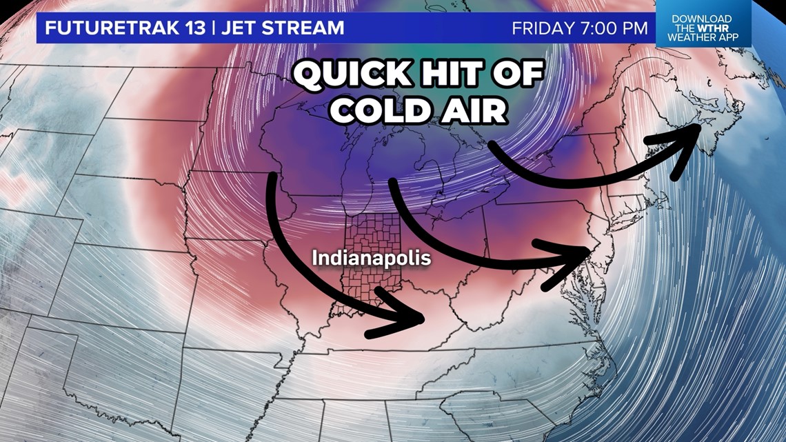
Tracking the quick shot of cold air
A cold-core low will be moving south for the end of the week into the Great Lakes. As a cold front hits Thursday and Friday, Lake Michigan will help enhance the clouds with some scattered snow showers across Indiana for Friday evening and Friday night.

When can I expect snow showers?
After rain on Thursday, we may get some sunshine Friday morning. Later in the afternoon, the cold-core low will start approaching central Indiana, bringing some more clouds at times, with some scattered flurries.
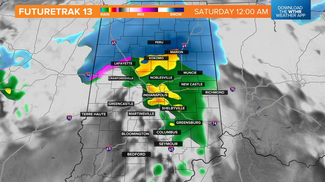
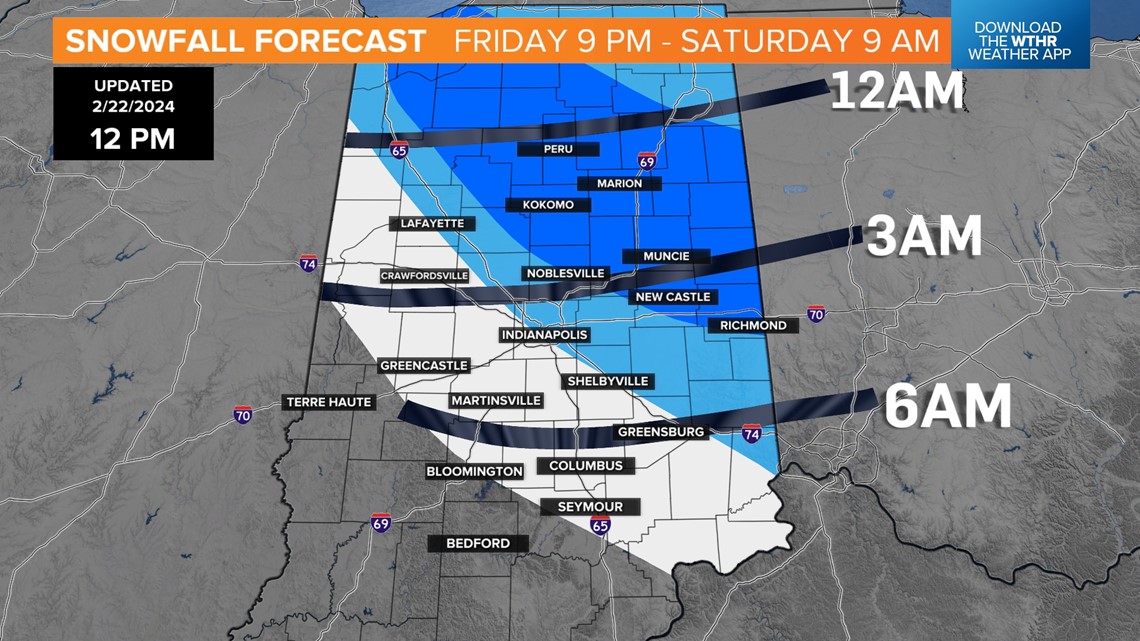
Northern Indiana: Friday 2-11 p.m.
Central Indiana: Friday 5 p.m.-Saturday 4 a.m.
Southern Indiana: Friday 10 p.m.-Saturday 7 a.m.

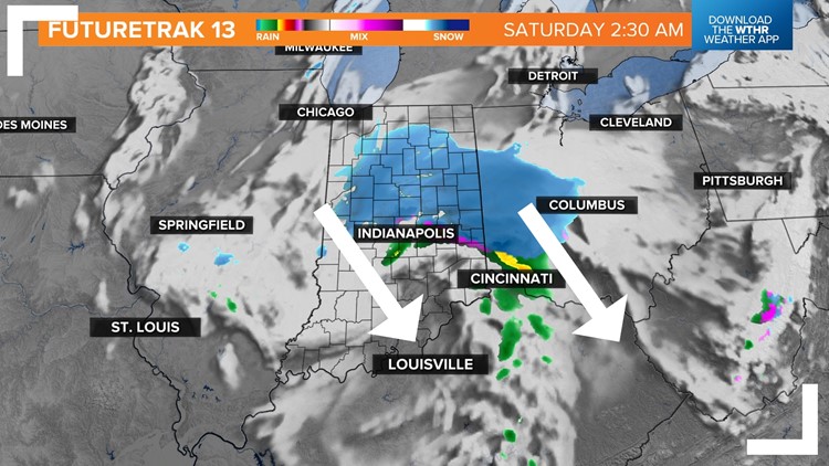
How much snow can I get?
This is not a winter storm. Don't expect much accumulation. Many of us may see some light flurries, but areas in the darker blue (see map below) may get some dustings in spots. That doesn't mean everyone will get a dusting, but if you want to see some of the snowflakes stick, you'll have to be in the darker blue.

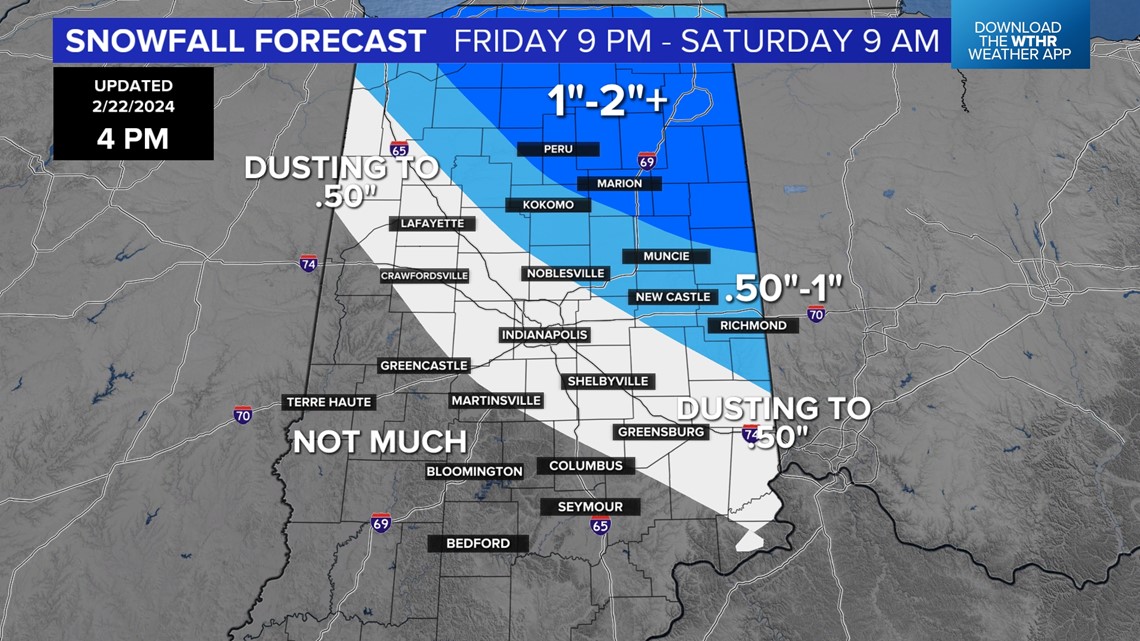
Areas in white may see some brief snow showers, but minimal accumulations at most are expected. Generally, expect up to a dusting west and south of Indianapolis. The light blue areas may get up to an inch in spots, while the best chance for an inch or even more will be in the darker blue.
Living in one of the zones does not guarantee snow chances. This map is meant to highlight areas that have the best chance for flurries. A few locations may even see some of the flakes stick.
When will the snow begin?
This system is hitting overnight Friday into Saturday. Northern Indiana will switch over to snow showers around midnight. Central Indiana will switch over near 2-4 a.m. Southern Indiana may not switch over until just before sunrise. A few hours with some snow may be able to coat grassy surfaces. A few roads may temporarily become slick, especially northeast toward Marion, Muncie, New Castle and Richmond.

What kind of impacts can I expect?
There will be either no impact or very minimal impacts across Indiana. The best chance to see some snowflakes sticking would be some grassy surfaces and fields, plus cold-elevated surfaces like mailboxes. This is more just something to possibly see rather than something that impacts you by the start of the weekend.