INDIANA, USA — Tropical storm / hurricane Beryl continues on its more northerly path over the western Gulf of Mexico. It is expected to make landfall at or near Category 1 hurricane status along the coast of Mexico south of Galveston. Once it gets back on land, the winds will dramatically decrease, however the storm will carry a lot of rainfall potential across parts of the United States, including Indiana.
Tap HERE to track the storm with our interactive radar.
Once the storm gets onto the land, it will quickly weaken to a low pressure system. However a front from the west and the lowering of the jet stream will help carry this storm northwest and keep the pressure low enough that it can still create rain, sometimes heavy rain, for much of the Ouachitas, Ozarks, and Ohio River Valley.
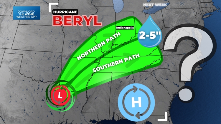
Indiana and Kentucky are officially in the National Hurricane Center's path for Beryl. The "L" stands for a post tropical low pressure. The cone gets wider as it goes north because there is still some uncertainty on where the storm goes next thanks to the influence of a front to the northwest.

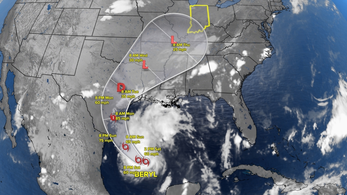
If the front comes in faster, it will knock the storm to the right (eastern side) of the track. If the front is slow and the jet stream does not drop as much south, the storm could take to the left (western side) of the track.
However, no matter where the center of the storm is, the eastern side is likely to be the rainiest side, the side that is most connected with the Gulf of Mexico.
Where will the heavy rain go?
After taking the overall path in consideration, let's chat about the rain chance. We created two green zones. There is a northern option and a southern option.
Currently the storm is favoring a northerly path, which gives Indiana the higher rain chance. This is due to a stronger high pressure, not allowing the rain to go much farther south.

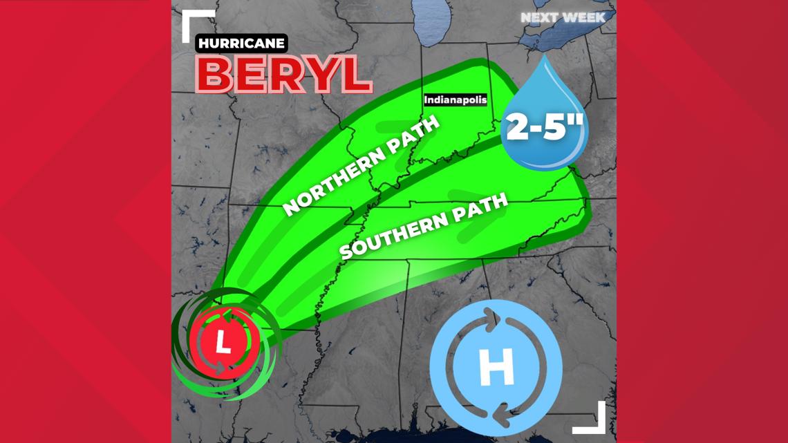
Inside the two green zones is the potential for some heavy rain. In some spots there could be 2-5 inches of rainfall, which would be very beneficial for parts of Arkansas, Indiana, Kentucky, Tennessee, and Illinois. Southern Indiana is in a level 1 drought and could use the rain.
The band of heaviest rain may only be 100 miles wide in parts. Some will get soaked while others may just a quarter inch of rain next week.
What about Indiana?
If Beryl takes the northern path, we will have a good chance for some rain, especially in southern Indiana. A few inches could be possible. . Areas north of Indy could get an inch. That would be very beneficial across the state. Right now we are favoring a northerly path, which gives Indian the higher rain chance. Within Indiana, it is still a toss-up for where the heaviest rain band goes, but at least we have a decent shot for some decent rain.

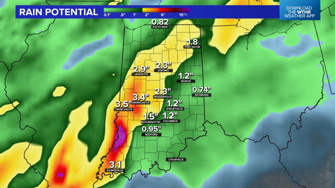
If Beryl takes the southern path, just expect slim pickings for rain. A quarter inch here or there is possible while Kentucky get a few inches of rain.
The best chance for rain next week will be Wednesday and Thursday.
Stay tuned.
— 13News Meteorologist Matt Standridge